Rumford, Falkirk
| Rumford | |
.jpg) Nicolton Road, Rumford |
|
 Rumford |
|
| Population | 421 [1] (2001 census) |
|---|---|
| OS grid reference | NS934771 |
| Civil parish | Muiravonside |
| Council area | Falkirk |
| Lieutenancy area | Stirling and Falkirk |
| Country | Scotland |
| Sovereign state | United Kingdom |
| Post town | FALKIRK |
| Postcode district | FK2 |
| Dialling code | 01324 |
| EU Parliament | Scotland |
| UK Parliament | Linlithgow and East Falkirk |
| Scottish Parliament | Falkirk East |
| Website | falkirk.gov.uk |
Coordinates: 55°58′30″N 3°42′32″W / 55.975050°N 3.70892°W
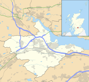
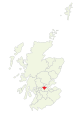
Rumford is a small village between Maddiston and Polmont in the Falkirk council area, of Scotland.
The village has a population of around 421.[1]
See also
References
- 1 2 No 3 - 2001 Census Population of settlements and wards www.falkirk.gov.uk. Retrieved 2011-04-27
External links
| Wikimedia Commons has media related to Rumford, Scotland. |
This article is issued from Wikipedia - version of the 3/24/2016. The text is available under the Creative Commons Attribution/Share Alike but additional terms may apply for the media files.