Tamfourhill
| Tamfourhill | |
| Scottish Gaelic: Tom a' Phùir | |
.jpg) These modern houses are close to the site of Tamfourhill, which, apparently vanished, like so many other old buildings, in the second half of the 20th century. |
|
 Tamfourhill |
|
| OS grid reference | NS858797 |
|---|---|
| Civil parish | Falkirk |
| Council area | Falkirk |
| Lieutenancy area | Stirling and Falkirk |
| Country | Scotland |
| Sovereign state | United Kingdom |
| Post town | FALKIRK |
| Postcode district | FK1 |
| Dialling code | 01324 |
| Police | Scottish |
| Fire | Scottish |
| Ambulance | Scottish |
| EU Parliament | Scotland |
| UK Parliament | Falkirk |
| Scottish Parliament | Falkirk West |
Coordinates: 55°59′50″N 3°49′47″W / 55.9972°N 3.8297°W
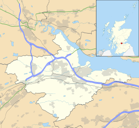
Tamfourhill is a working-class residential suburb of Falkirk within the Falkirk (council area), Scotland. It is located approximately 1.5 miles (2.5 kilometres) west of the city centre.[1] The Falkirk Wheel is located just to the northwest of the village. Tamfourhill includes the residential area between the south side of the Forth & Clyde Canal and the north side of the Union Canal.[2] It also contains the Tamfourhill Industrial Estate. To the west of the village is a well preserved part of the Antonine Wall, built in the 2nd century and Rough Castle.
References
- ↑ "Tamfourhill". Scottish Gazetteer. Retrieved 21 January 2011.
- ↑ "Tamfourhill". Central Scotland Police. Retrieved 21 January 2011.
External links
| Wikimedia Commons has media related to Tamfourhill. |
This article is issued from Wikipedia - version of the 12/11/2014. The text is available under the Creative Commons Attribution/Share Alike but additional terms may apply for the media files.