Roxas, Palawan
Not to be confused with Roxas, Capiz.
| Roxas | |
|---|---|
| Municipality | |
|
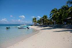
Coco Loco Island Resort in Roxas | |
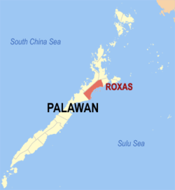 Map of Palawan with Roxas highlighted | |
.svg.png) Roxas Location within the Philippines | |
| Coordinates: 10°20′N 119°20′E / 10.333°N 119.333°ECoordinates: 10°20′N 119°20′E / 10.333°N 119.333°E | |
| Country | Philippines |
| Region | MIMAROPA (Region IV-B) |
| Province | Palawan |
| Congr. district | 1st district of Palawan |
| Founded | 1951 |
| Barangays | 31 |
| Government[1] | |
| • Mayor | Maria Angela V. Sabando |
| Area[2] | |
| • Total | 1,177.56 km2 (454.66 sq mi) |
| Population (2010)[3] | |
| • Total | 61,058 |
| • Density | 52/km2 (130/sq mi) |
| Time zone | PST (UTC+8) |
| Zip Code | 5308 |
| Dialing code | 48 |
Roxas is a municipality located on the eastern coast of the provincial island of Palawan, Philippines. As of 2010, it had a population of 61,058 people.[3]
Roxas was created in 1951 from the barrios of Tinitian, Caramay, Rizal, Del Pilar, Malcampo, Tumarbong, Taradungan, Ilian, and Capayas of Puerto Princesa.[4]
Barangays
Roxas is politically subdivided into 31 barangays.[2] Bagong Bayan was formerly a sitio of Ilian which is now part of the municipality of Dumaran).[5]
- Abaroan
- Antonino
- Bagong Bayan
- Caramay
- Dumarao
- Iraan
- Jolo
- Magara (Arasan)
- Malcampo
- Mendoza
- Narra (Minara)
- New Barbacan (Retac)
- New Cuyo
- Barangay 1 (Pob.)
- Rizal
- Salvacion
- San Isidro
- San Jose
- San Miguel
- San Nicolas
- Sandoval
- Tagumpay
- Taradungan
- Tinitian
- Tumarbong
- Barangay II (Pob.)
- Barangay III (Pob.)
- Barangay IV (Pob.)
- Barangay V (Pob.) (Porao Islan)
- Barangay VI (Pob.) (Johnson Is)
- Nicanor Zabala
Demographics
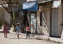
Children walking in the street in Roxas
| Population census of Roxas | ||
|---|---|---|
| Year | Pop. | ±% p.a. |
| 1990 | 36,604 | — |
| 1995 | 44,370 | +3.67% |
| 2000 | 47,242 | +1.35% |
| 2007 | 51,084 | +1.08% |
| 2010 | 61,058 | +6.71% |
| Source: National Statistics Office[3][6] | ||
References
- ↑ "Municipalities". Quezon City, Philippines: Department of the Interior and Local Government. Retrieved 15 November 2012.
- 1 2 "Province: PALAWAN". PSGC Interactive. Makati City, Philippines: National Statistical Coordination Board. Retrieved 15 November 2012.
- 1 2 3 "Total Population by Province, City, Municipality and Barangay: as of May 1, 2010" (PDF). 2010 Census of Population and Housing. National Statistics Office. Retrieved 15 November 2012.
- ↑ "An act creating the municipality of Roxas, province of Palawan". LawPH.com. Retrieved 2011-04-09.
- ↑ "An Act Converting the Sitio of Bagongbayan in the Barrio of Ilian, Municipality of Roxas, Province of Palawan, into a Barrio". LawPH.com. Retrieved 2011-04-12.
- ↑ "Province of Palawan". Municipality Population Data. LWUA Research Division. Retrieved 18 July 2013.
External links
| Wikivoyage has a travel guide for Roxas (Palawan). |
- Philippine Standard Geographic Code
- Philippine Census Information
- Local Governance Performance Management System
 |
San Vicente | Taytay | Dumaran | |
| |
||||
| ||||
| | ||||
| Puerto Princesa | |
Sulu Sea |
Puerto Princesa (capital) | |
| Municipalities | |
| Highly urbanized city |
|
This article is issued from Wikipedia - version of the 10/8/2016. The text is available under the Creative Commons Attribution/Share Alike but additional terms may apply for the media files.