Araceli, Palawan
| Araceli | |
|---|---|
| Municipality | |
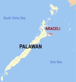 Map of Palawan with Araceli highlighted | |
.svg.png) Araceli Location within the Philippines | |
| Coordinates: 10°20′N 119°36′E / 10.333°N 119.600°ECoordinates: 10°20′N 119°36′E / 10.333°N 119.600°E | |
| Country | Philippines |
| Region | MIMAROPA (Region IV-B) |
| Province | Palawan |
| Congr. district | 1st district |
| Formed | 1961 |
| Barangays | 13 |
| Government[1] | |
| • Mayor | Noel A.Beronio |
| Area[2] | |
| • Total | 204.30 km2 (78.88 sq mi) |
| Population (2010)[3] | |
| • Total | 14,113 |
| • Density | 69/km2 (180/sq mi) |
| Time zone | PST (UTC+8) |
| Zip Code | 5311 |
| Dialing code | 48 |
| Website |
aracelipalawan |
Araceli is a fourth class municipality in the province of Palawan, Philippines. According to the 2010 census, it has a population of 14,113 people.[3]
The municipality covers roughly the northern half of Dumaran Island. Cuyono is the principal language of the area.
Araceli was formerly part of Dumaran Municipality, but was made into a separate municipality in 1961.[4] The Catholic Parish is Nuestra Sra. de Araceli, that can be translated to "Altar of the Sky" (from ara, meaning altar; and celi, meaning sky).
Barangays
Araceli is politically subdivided into 13 barangays.[2]
- Tinintinan
- Dalayawan
- San Jose De Oro
- Taloto
- Santo Niño
- Balogo
- Lumacad
- Mauringuen
- Maduldulon
- Osmeña
- Dagman
- Calandagan (formerly Tudela[5])
- Poblacion
Demographics
| Population census of Araceli | ||
|---|---|---|
| Year | Pop. | ±% p.a. |
| 1990 | 8,708 | — |
| 1995 | 10,556 | +3.67% |
| 2000 | 10,894 | +0.68% |
| 2007 | 13,233 | +2.72% |
| 2010 | 14,113 | +2.37% |
| Source: National Statistics Office[3][6] | ||
References
- ↑ "Municipalities". Quezon City, Philippines: Department of the Interior and Local Government. Archived from the original on 25 January 2013. Retrieved 15 November 2012.
- 1 2 "Province: PALAWAN". PSGC Interactive. Makati City, Philippines: National Statistical Coordination Board. Archived from the original on 14 November 2012. Retrieved 15 November 2012.
- 1 2 3 "Total Population by Province, City, Municipality and Barangay: as of May 1, 2010" (PDF). 2010 Census of Population and Housing. National Statistics Office. Archived from the original (PDF) on 15 November 2012. Retrieved 15 November 2012.
- ↑ "Araceli" (PDF). Provincial Government of Palawan. Retrieved 15 November 2012.
- ↑ "An Act Changing the Name of Barrio Tudela, Municipality of Araceli, Province of Palawan, to Calandagan". LawPH.com. Retrieved 2011-04-12.
- ↑ "Province of Palawan". Municipality Population Data. LWUA Research Division. Retrieved 18 July 2013.
External links
- Philippine Standard Geographic Code
- Philippine Census Information
- Local Governance Performance Management System
 |
Sulu Sea | | ||
| Taytay | |
Sulu Sea / Cuyo | ||
| ||||
| | ||||
| Dumaran |
Puerto Princesa (capital) | |
| Municipalities | |
| Highly urbanized city |
|
This article is issued from Wikipedia - version of the 10/16/2016. The text is available under the Creative Commons Attribution/Share Alike but additional terms may apply for the media files.