Peyrabout
| Peyrabout | |
|---|---|
|
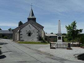
A view of the church and the war memorial in Peyrabout | |
 Peyrabout | |
|
Location within Nouvelle-Aquitaine region  Peyrabout | |
| Coordinates: 46°06′29″N 1°54′46″E / 46.1081°N 1.9128°ECoordinates: 46°06′29″N 1°54′46″E / 46.1081°N 1.9128°E | |
| Country | France |
| Region | Nouvelle-Aquitaine |
| Department | Creuse |
| Arrondissement | Guéret |
| Canton | Ahun |
| Intercommunality | Pays Creuse-Thaurion-Gartempe |
| Government | |
| • Mayor (2008–2014) | Jean-Paul Brignoli |
| Area1 | 8.91 km2 (3.44 sq mi) |
| Population (2008)2 | 140 |
| • Density | 16/km2 (41/sq mi) |
| Time zone | CET (UTC+1) |
| • Summer (DST) | CEST (UTC+2) |
| INSEE/Postal code | 23150 / 23000 |
| Elevation |
446–685 m (1,463–2,247 ft) (avg. 600 m or 2,000 ft) |
|
1 French Land Register data, which excludes lakes, ponds, glaciers > 1 km² (0.386 sq mi or 247 acres) and river estuaries. 2 Population without double counting: residents of multiple communes (e.g., students and military personnel) only counted once. | |
Peyrabout is a commune in the Creuse department in the Nouvelle-Aquitaine region in central France.
Geography
A small area of forestry and farming comprising the village and one hamlet situated just 5 miles (8.0 km) south of Guéret, at the junction of the D3 and the D52.
Population
| Historical population | ||
|---|---|---|
| Year | Pop. | ±% |
| 1962 | 83 | — |
| 1968 | 111 | +33.7% |
| 1975 | 114 | +2.7% |
| 1982 | 171 | +50.0% |
| 1990 | 162 | −5.3% |
| 1999 | 158 | −2.5% |
| 2008 | 140 | −11.4% |
Sights
- The church of St. Madeleine, dating from the twelfth century.
See also
References
External links
| Wikimedia Commons has media related to Peyrabout. |
- Peyrabout on the Quid website (French)
This article is issued from Wikipedia - version of the 11/11/2016. The text is available under the Creative Commons Attribution/Share Alike but additional terms may apply for the media files.