La Souterraine
| La Souterraine | ||
|---|---|---|
|
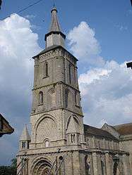
The bell tower of the church in La Souterraine | ||
| ||
 La Souterraine | ||
|
Location within Nouvelle-Aquitaine region  La Souterraine | ||
| Coordinates: 46°14′15″N 1°29′10″E / 46.2374°N 1.4862°ECoordinates: 46°14′15″N 1°29′10″E / 46.2374°N 1.4862°E | ||
| Country | France | |
| Region | Nouvelle-Aquitaine | |
| Department | Creuse | |
| Arrondissement | Guéret | |
| Canton | La Souterraine | |
| Intercommunality | Pays Sostranien | |
| Government | ||
| • Mayor (2008–2014) | Jean-François Muguay | |
| Area1 | 37.07 km2 (14.31 sq mi) | |
| Population (2008)2 | 5,435 | |
| • Density | 150/km2 (380/sq mi) | |
| Time zone | CET (UTC+1) | |
| • Summer (DST) | CEST (UTC+2) | |
| INSEE/Postal code | 23176 / 23300 | |
| Elevation | 284–456 m (932–1,496 ft) | |
|
1 French Land Register data, which excludes lakes, ponds, glaciers > 1 km² (0.386 sq mi or 247 acres) and river estuaries. 2 Population without double counting: residents of multiple communes (e.g., students and military personnel) only counted once. | ||

La Souterraine (Occitan: La Sotarrana) is a commune in the Creuse department in the Nouvelle-Aquitaine region in central France.
Geography
An area of farming and light industry comprising the town and a few small hamlets situated some 20 miles (32 km) west of Guéret at the junction of the D1, D912, D951 and the N145 roads. The small river Sédelle, a tributary of the Creuse River, flows through the town. It is also served by a TER railway link.
The Benaize, a tributary of the Anglin, has its source in the commune.
The Brame, a tributary of the Gartempe, has its source in the commune.
History
There is evidence of pre-Roman occupation here, attested by the discovery of stone age tools and a menhir. Remains of Roman villas and temples have been unearthed. In medieval times, a church and fortified walls were built. The name of the town, translating as ‘subterranean’, comes from the underground parts of the church, the crypt.
Population
| Historical population | ||
|---|---|---|
| Year | Pop. | ±% |
| 1962 | 4,718 | — |
| 1968 | 5,104 | +8.2% |
| 1975 | 5,302 | +3.9% |
| 1982 | 5,690 | +7.3% |
| 1990 | 5,490 | −3.5% |
| 1999 | 5,320 | −3.1% |
| 2008 | 5,435 | +2.2% |
Sights
- The church dating from the eleventh century, with its Roman crypt.
- The fifteenth-century Manorhouse de Châteaurenaud.
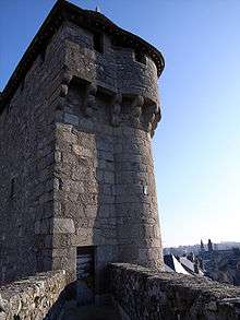
- The thirteenth-century gate, the Porte de St.Jean, and the rest of the ramparts.
- A feudal motte, circular tower and the castle at Bridiers.
- The eighteenth-century chapel of the hospital.
- The ancient chapel of Sainte-Eutrope.
- The fourteenth-century church at Bussière-Madeleine.
See also
References
External links
- Official website of La Souterraine (French)
| Wikimedia Commons has media related to La Souterraine. |