Chavanat
| Chavanat | |
|---|---|
|
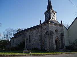
The church in Chavanat | |
 Chavanat | |
|
Location within Nouvelle-Aquitaine region  Chavanat | |
| Coordinates: 45°57′13″N 1°57′54″E / 45.9536°N 1.965°ECoordinates: 45°57′13″N 1°57′54″E / 45.9536°N 1.965°E | |
| Country | France |
| Region | Nouvelle-Aquitaine |
| Department | Creuse |
| Arrondissement | Aubusson |
| Canton | Saint-Sulpice-les-Champs |
| Intercommunality | Pays Creuse-Thaurion-Gartempe |
| Government | |
| • Mayor (2008–2014) | Guy Desloges |
| Area1 | 12.73 km2 (4.92 sq mi) |
| Population (2008)2 | 130 |
| • Density | 10/km2 (26/sq mi) |
| Time zone | CET (UTC+1) |
| • Summer (DST) | CEST (UTC+2) |
| INSEE/Postal code | 23060 / 23250 |
| Elevation |
471–647 m (1,545–2,123 ft) (avg. 500 m or 1,600 ft) |
|
1 French Land Register data, which excludes lakes, ponds, glaciers > 1 km² (0.386 sq mi or 247 acres) and river estuaries. 2 Population without double counting: residents of multiple communes (e.g., students and military personnel) only counted once. | |
Chavanat (Occitan: Chavanac) is a commune in the Creuse department in the Nouvelle-Aquitaine region in central France.
Geography
An area of forestry and farming comprising the village and several hamlets, situated in the valley of the river Thaurion, some 8 miles (13 km) west of Aubusson at the junctions of the D3, D10 and the D941 roads.
Population
| Historical population | ||
|---|---|---|
| Year | Pop. | ±% |
| 1962 | 140 | — |
| 1968 | 182 | +30.0% |
| 1975 | 202 | +11.0% |
| 1982 | 154 | −23.8% |
| 1990 | 144 | −6.5% |
| 1999 | 127 | −11.8% |
| 2008 | 130 | +2.4% |
Sights
- The church, dating from the thirteenth century.
See also
References
External links
- Chavanat on the Quid website (French)
| Wikimedia Commons has media related to Chavanat. |
This article is issued from Wikipedia - version of the 11/20/2016. The text is available under the Creative Commons Attribution/Share Alike but additional terms may apply for the media files.