Donnemarie-Dontilly
| Donnemarie-Dontilly | |
|---|---|
|
Donnemarie-Dontilly | |
 Donnemarie-Dontilly | |
|
Location within Île-de-France region  Donnemarie-Dontilly | |
| Coordinates: 48°28′33″N 3°07′38″E / 48.4758°N 3.1272°ECoordinates: 48°28′33″N 3°07′38″E / 48.4758°N 3.1272°E | |
| Country | France |
| Region | Île-de-France |
| Department | Seine-et-Marne |
| Arrondissement | Provins |
| Canton | Donnemarie-Dontilly |
| Intercommunality | Montois |
| Government | |
| • Mayor (2008–2014) | Serge Rossière-Rollin |
| Area1 | 12.07 km2 (4.66 sq mi) |
| Population (2012)2 | 2,876 |
| • Density | 240/km2 (620/sq mi) |
| Time zone | CET (UTC+1) |
| • Summer (DST) | CEST (UTC+2) |
| INSEE/Postal code | 77159 / 77520 |
| Elevation | 68–139 m (223–456 ft) |
|
1 French Land Register data, which excludes lakes, ponds, glaciers > 1 km² (0.386 sq mi or 247 acres) and river estuaries. 2 Population without double counting: residents of multiple communes (e.g., students and military personnel) only counted once. | |
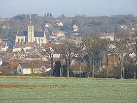
Donnemarie-Dontilly is a commune in the Seine-et-Marne department in the Île-de-France region in north-central France.
Demographics
Inhabitants of Donnemarie-Dontilly are called Donnemaritains.
See also
References
External links
| Wikimedia Commons has media related to Donnemarie-Dontilly. |
- Town Hall of Donnemarie-Dontilly (French)
- 1999 Land Use, from IAURIF (Institute for Urban Planning and Development of the Paris-Île-de-France région) (English)
- French Ministry of Culture list for Donnemarie-Dontilly (French)
- Map of Donnemarie-Dontilly on Michelin (English)
This article is issued from Wikipedia - version of the 7/16/2015. The text is available under the Creative Commons Attribution/Share Alike but additional terms may apply for the media files.