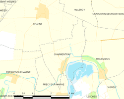
Charmentray
| Charmentray | ||
|---|---|---|
|
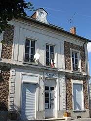
The town hall of Charmentray | ||
| ||
 | ||
| Coordinates: 48°56′43″N 2°46′35″E / 48.9454°N 2.7765°ECoordinates: 48°56′43″N 2°46′35″E / 48.9454°N 2.7765°E | ||
| Country | France | |
| Region | Île-de-France | |
| Department | Seine-et-Marne | |
| Arrondissement | Meaux | |
| Canton | Claye-Souilly | |
| Intercommunality | Plaines et monts de France | |
| Government | ||
| • Mayor (2014–2020) | Bernard Lenfant | |
| Area1 | 4.67 km2 (1.80 sq mi) | |
| Population (2013)2 | 260 | |
| • Density | 56/km2 (140/sq mi) | |
| Time zone | CET (UTC+1) | |
| • Summer (DST) | CEST (UTC+2) | |
| INSEE/Postal code | 77094 / 77410 | |
| Elevation | 40–95 m (131–312 ft) | |
|
1 French Land Register data, which excludes lakes, ponds, glaciers > 1 km² (0.386 sq mi or 247 acres) and river estuaries. 2 Population without double counting: residents of multiple communes (e.g., students and military personnel) only counted once. | ||
.svg.png)
Charmentray is a commune in the Seine-et-Marne department in the Île-de-France region in north-central France.
Demographics
The inhabitants are called Carmentraciens.
See also
References
External links
| Wikimedia Commons has media related to Charmentray. |
- 1999 Land Use, from IAURIF (Institute for Urban Planning and Development of the Paris-Île-de-France région) (English)
- Map of Charmentray on Michelin (English)
This article is issued from Wikipedia - version of the 11/20/2016. The text is available under the Creative Commons Attribution/Share Alike but additional terms may apply for the media files.