Courcelles, Belgium
| Courcelles | |||
|---|---|---|---|
| Municipality | |||
|
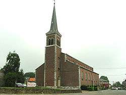
St. Lambert's church | |||
| |||
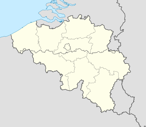 Courcelles Location in Belgium | |||
|
Location of Courcelles in Hainaut 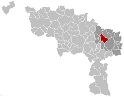 | |||
| Coordinates: 50°28′N 04°22′E / 50.467°N 4.367°ECoordinates: 50°28′N 04°22′E / 50.467°N 4.367°E | |||
| Country | Belgium | ||
| Community | French Community | ||
| Region | Wallonia | ||
| Province | Hainaut | ||
| Arrondissement | Charleroi | ||
| Government | |||
| • Mayor | Caroline Taquin (MR) | ||
| • Governing party/ies | MR, CDH, Ecolo | ||
| Area | |||
| • Total | 48.04 km2 (18.55 sq mi) | ||
| Population (1 January 2016)[1] | |||
| • Total | 31,217 | ||
| • Density | 650/km2 (1,700/sq mi) | ||
| Postal codes | 6180-6183 | ||
| Area codes | 071 | ||
| Website | www.courcelles.be | ||


Courcelles (French pronunciation: [kuʁ.sɛl]) is a Walloon municipality located in the Belgian province of Hainaut. As of January 1, 2006, Courcelles had a total population of 29,626. The total area is 44.24 km² which gives a population density of 670 inhabitants per km².
The municipality consists of the following sub-municipalities: Courcelles proper, Gouy-lez-Piéton, Souvret, and Trazegnies.
In 1944, the town was the site of the Courcelles Massacre of 20 civilians by Belgian collaborators. The event is commemorated by a plaque at the site.

The coal mine "6 périer", Souvret
References
- ↑ Population per municipality as of 1 January 2016 (XLS; 397 KB)
External links
-
 Media related to Courcelles, Belgium at Wikimedia Commons
 |
Seneffe | |
Pont-à-Celles | |
| Chapelle-lez-Herlaimont | |
|||
| ||||
| | ||||
| Fontaine-l'Évêque | Charleroi |
This article is issued from Wikipedia - version of the 12/1/2016. The text is available under the Creative Commons Attribution/Share Alike but additional terms may apply for the media files.