Cercié
| Cercié | |
|---|---|
|
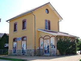
The former railway station in Cercié | |
 Cercié | |
|
Location within Auvergne-Rhône-Alpes region  Cercié | |
| Coordinates: 46°07′13″N 4°40′17″E / 46.1203°N 4.6714°ECoordinates: 46°07′13″N 4°40′17″E / 46.1203°N 4.6714°E | |
| Country | France |
| Region | Auvergne-Rhône-Alpes |
| Department | Rhône |
| Arrondissement | Villefranche-sur-Saône |
| Canton | Belleville |
| Intercommunality | Communauté de communes Beaujolais-Val-de-Saône |
| Government | |
| • Mayor (2008–2014) | Alain Michel |
| Area1 | 4.94 km2 (1.91 sq mi) |
| Population (2004)2 | 911 |
| • Density | 180/km2 (480/sq mi) |
| Time zone | CET (UTC+1) |
| • Summer (DST) | CEST (UTC+2) |
| INSEE/Postal code | 69036 / 69220 |
| Elevation |
199–293 m (653–961 ft) (avg. 222 m or 728 ft) |
|
1 French Land Register data, which excludes lakes, ponds, glaciers > 1 km² (0.386 sq mi or 247 acres) and river estuaries. 2 Population without double counting: residents of multiple communes (e.g., students and military personnel) only counted once. | |
Cercié is a rural commune in the Rhône department in eastern France.
See also
Communes of the Rhône department
References
| Wikimedia Commons has media related to Cercié. |
This article is issued from Wikipedia - version of the 3/15/2016. The text is available under the Creative Commons Attribution/Share Alike but additional terms may apply for the media files.