Chaponnay
| Chaponnay | ||
|---|---|---|
|
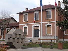
The town hall in Chaponnay | ||
| ||
 Chaponnay | ||
|
Location within Auvergne-Rhône-Alpes region  Chaponnay | ||
| Coordinates: 45°37′42″N 4°56′13″E / 45.6283°N 4.9369°ECoordinates: 45°37′42″N 4°56′13″E / 45.6283°N 4.9369°E | ||
| Country | France | |
| Region | Auvergne-Rhône-Alpes | |
| Department | Rhône | |
| Canton | Saint-Symphorien-d'Ozon | |
| Government | ||
| • Mayor (2008–2014) | Raymond Durand | |
| Area1 | 18.89 km2 (7.29 sq mi) | |
| Population (2012)2 | 3,805 | |
| • Density | 200/km2 (520/sq mi) | |
| Time zone | CET (UTC+1) | |
| • Summer (DST) | CEST (UTC+2) | |
| INSEE/Postal code | 69270 / 69970 | |
| Elevation |
192–367 m (630–1,204 ft) (avg. 220 m or 720 ft) | |
|
1 French Land Register data, which excludes lakes, ponds, glaciers > 1 km² (0.386 sq mi or 247 acres) and river estuaries. 2 Population without double counting: residents of multiple communes (e.g., students and military personnel) only counted once. | ||
.svg.png)
Chaponnay is a commune in the Rhône department in eastern France.
See also
Communes of the Rhône department
References
| Wikimedia Commons has media related to Chaponnay. |
This article is issued from Wikipedia - version of the 3/15/2016. The text is available under the Creative Commons Attribution/Share Alike but additional terms may apply for the media files.