Castelplanio
| Castelplanio | |
|---|---|
| Comune | |
| Comune di Castelplanio | |
|
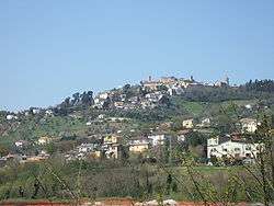
Castelplanio (upon the hill) with its major frazione, Macine, in the foreground | |
 Castelplanio Location of Castelplanio in Italy | |
| Coordinates: 43°30′N 13°5′E / 43.500°N 13.083°ECoordinates: 43°30′N 13°5′E / 43.500°N 13.083°E | |
| Country | Italy |
| Region | Marche |
| Province / Metropolitan city | Province of Ancona (AN) |
| Area | |
| • Total | 15.1 km2 (5.8 sq mi) |
| Population (Dec. 2004) | |
| • Total | 3,303 |
| • Density | 220/km2 (570/sq mi) |
| Time zone | CET (UTC+1) |
| • Summer (DST) | CEST (UTC+2) |
| Postal code | 60031 |
| Dialing code | 0731 |
Castelplanio is a comune (municipality) in the Province of Ancona in the Italian region Marche, located about 35 kilometres (22 mi) southwest of Ancona. As of 31 December 2004, it had a population of 3,303 and an area of 15.1 square kilometres (5.8 sq mi).[1]
The municipality of Castelplanio contains the frazioni (subdivisions) Macine, Pozzetto, Borgo Loreto and Piagge.
Castelplanio borders the following municipalities: Belvedere Ostrense, Maiolati Spontini, Poggio San Marcello, Rosora.
Its patron saint is Saint Joseph.[2]
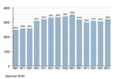
Demographic evolution
References
- ↑ All demographics and other statistics: Italian statistical institute Istat.
- ↑ Saint Joseph at sqpn.comRetrieved 5 April 2013
This article is issued from Wikipedia - version of the 1/31/2015. The text is available under the Creative Commons Attribution/Share Alike but additional terms may apply for the media files.