Balleray
| Balleray | |
|---|---|
|
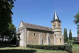
The church of Saint-Blaise, in Balleray | |
 Balleray | |
|
Location within Bourgogne-Franche-Comté region  Balleray | |
| Coordinates: 47°04′29″N 3°16′46″E / 47.0747°N 3.2794°ECoordinates: 47°04′29″N 3°16′46″E / 47.0747°N 3.2794°E | |
| Country | France |
| Region | Bourgogne-Franche-Comté |
| Department | Nièvre |
| Arrondissement | Nevers |
| Canton | Guérigny |
| Intercommunality | Le Bon Pays |
| Government | |
| • Mayor (2008–2014) | Jean-Luc Conception |
| Area1 | 16.08 km2 (6.21 sq mi) |
| Population (2009)2 | 203 |
| • Density | 13/km2 (33/sq mi) |
| Time zone | CET (UTC+1) |
| • Summer (DST) | CEST (UTC+2) |
| INSEE/Postal code | 58022 / 58130 |
| Elevation | 208–375 m (682–1,230 ft) |
|
1 French Land Register data, which excludes lakes, ponds, glaciers > 1 km² (0.386 sq mi or 247 acres) and river estuaries. 2 Population without double counting: residents of multiple communes (e.g., students and military personnel) only counted once. | |
Balleray is a commune in the Nièvre department in central France.
Population
| Historical population | ||
|---|---|---|
| Year | Pop. | ±% |
| 1962 | 113 | — |
| 1968 | 132 | +16.8% |
| 1975 | 125 | −5.3% |
| 1982 | 162 | +29.6% |
| 1990 | 192 | +18.5% |
| 1999 | 221 | +15.1% |
| 2006 | 208 | −5.9% |
| 2009 | 203 | −2.4% |
See also
References
| Wikimedia Commons has media related to Balleray. |
This article is issued from Wikipedia - version of the 9/16/2015. The text is available under the Creative Commons Attribution/Share Alike but additional terms may apply for the media files.