Angadanan, Isabela
For the old Angadanan town (Angadanan Viejo), see Alicia, Isabela.
| Angadanan | ||
|---|---|---|
| Municipality | ||
| ||
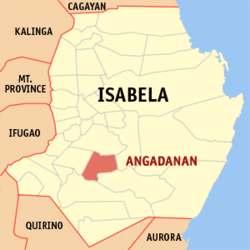 Map of Isabela showing the location of Angadanan | ||
.svg.png) Angadanan Location within the Philippines | ||
| Coordinates: 16°45′N 121°45′E / 16.750°N 121.750°ECoordinates: 16°45′N 121°45′E / 16.750°N 121.750°E | ||
| Country | Philippines | |
| Region | Cagayan Valley (Region II) | |
| Province | Isabela | |
| District | 3rd District, Isabela | |
| Founded | 1745 | |
| Barangays | 59 | |
| Government[1] | ||
| • Mayor | Lourdes S. Panganiban | |
| Area[2] | ||
| • Total | 204.40 km2 (78.92 sq mi) | |
| Population (2015)[3] | ||
| • Total | 43,061 | |
| • Density | 210/km2 (550/sq mi) | |
| Time zone | PST (UTC+8) | |
| ZIP code | 3307 | |
| Dialing code | 78 | |
| Income class | 3rd class; partially urban | |

Angadanan (or Angadanan Nuevo) is a third class municipality in the province of Isabela, Philippines. According to the 2015 census, it has a population of 43,061 people.[3]
Barangays Today
Barangay Centro 2
Barangay Captain: Capt. Eduardo Baracao
Hectares: 237
Population: 2,294
Occupation: Farming
Ethnic Groups: Ilokanos, Gaddang, Ibanags, Yogads and Tagalogs
Barangays
Angadanan is politically subdivided into 59 barangays.[2]
- Allangigan
- Aniog
- Baniket
- Bannawag
- Bantug
- Barangcuag
- Baui
- Bonifacio
- Buenavista
- Bunnay
- Calabayan-Minanga
- Calaccab
- Calaocan
- Kalusutan
- Campanario
- Canangan
- Centro I (Pob.)
- Centro II (Pob.)
- Centro III (Pob.)
- Consular
- Cumu
- Dalakip
- Dalenat
- Dipaluda
- Duroc
- Lourdes (El Escaño)
- Esperanza
- Fugaru
- Liwliwa
- Ingud Norte
- Ingud Sur
- La Suerte
- Lomboy
- Loria
- Mabuhay
- Macalauat
- Macaniao
- Malannao
- Malasin
- Mangandingay
- Minanga Proper
- Pappat
- Pissay
- Ramona
- Rancho Bassit
- Rang-ayan
- Salay
- San Ambrocio
- San Guillermo
- San Isidro
- San Marcelo
- San Roque
- San Vicente
- Santo Niño
- Saranay
- Sinabbaran
- Victory
- Viga
- Villa Domingo
Demographics
| Population census of Angadanan | ||
|---|---|---|
| Year | Pop. | ±% p.a. |
| 1990 | 32,548 | — |
| 1995 | 33,145 | +0.34% |
| 2000 | 36,788 | +2.26% |
| 2007 | 39,743 | +1.07% |
| 2010 | 40,143 | +0.37% |
| 2015 | 43,061 | +1.34% |
| Source: National Statistics Office[3] | ||
Climate
| Climate data for Angadanan, Isabela | |||||||||||||
|---|---|---|---|---|---|---|---|---|---|---|---|---|---|
| Month | Jan | Feb | Mar | Apr | May | Jun | Jul | Aug | Sep | Oct | Nov | Dec | Year |
| Average high °C (°F) | 29 (84) |
30 (86) |
32 (90) |
35 (95) |
35 (95) |
35 (95) |
34 (93) |
33 (91) |
32 (90) |
31 (88) |
30 (86) |
28 (82) |
32 (89.6) |
| Average low °C (°F) | 19 (66) |
20 (68) |
21 (70) |
23 (73) |
23 (73) |
24 (75) |
23 (73) |
23 (73) |
23 (73) |
22 (72) |
21 (70) |
20 (68) |
21.8 (71.2) |
| Average precipitation mm (inches) | 31.2 (1.228) |
23 (0.91) |
27.7 (1.091) |
28.1 (1.106) |
113.5 (4.469) |
141.4 (5.567) |
176.4 (6.945) |
236.6 (9.315) |
224.9 (8.854) |
247.7 (9.752) |
222.9 (8.776) |
178 (7.01) |
1,651.4 (65.023) |
| Average rainy days | 10 | 6 | 5 | 5 | 13 | 12 | 15 | 15 | 15 | 17 | 16 | 15 | 144 |
| Source: World Weather Online[4] | |||||||||||||
References
- ↑ "Official City/Municipal 2013 Election Results". Intramuros, Manila, Philippines: Commission on Elections (COMELEC). 11 September 2013. Retrieved 9 January 2014.
- 1 2 "Province: ISABELA". PSGC Interactive. Makati City, Philippines: National Statistical Coordination Board. Retrieved 9 January 2014.
- 1 2 3 "Total Population by Province, City, Municipality and Barangay: as of May 1, 2010" (PDF). 2010 Census of Population and Housing. National Statistics Office. Archived from the original (PDF) on 14 November 2013. Retrieved 9 January 2014.
- ↑ "Angadanan, Isabela: Average Temperatures and Rainfall". World Weather Online. Retrieved 3 November 2015.
External links
- Philippine Standard Geographic Code
- Philippine Census Information
- Municipality of Angadanan
- Local Governance Performance Management System
 |
Cauayan | San Mariano | | |
| Alicia | |
San Guillermo | ||
| ||||
| | ||||
| Echague |
Ilagan (capital) | |
| Municipalities |
|
| Component Cities | |
| Independent Component City |
|
| Barangays | |
This article is issued from Wikipedia - version of the 10/13/2016. The text is available under the Creative Commons Attribution/Share Alike but additional terms may apply for the media files.