Wirdum, Germany
For other places with the same name, see Wirdum.
| Wirdum | ||
|---|---|---|
| ||
 Wirdum | ||
Location of Wirdum within Aurich district 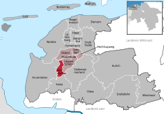
 | ||
| Coordinates: 53°28′39″N 7°12′18″E / 53.47750°N 7.20500°ECoordinates: 53°28′39″N 7°12′18″E / 53.47750°N 7.20500°E | ||
| Country | Germany | |
| State | Lower Saxony | |
| District | Aurich | |
| Municipal assoc. | Brookmerland | |
| Government | ||
| • Mayor | Martin Tuitjer (SEW) | |
| Area | ||
| • Total | 14.94 km2 (5.77 sq mi) | |
| Population (2015-12-31)[1] | ||
| • Total | 1,057 | |
| • Density | 71/km2 (180/sq mi) | |
| Time zone | CET/CEST (UTC+1/+2) | |
| Postal codes | 26529 | |
| Dialling codes | 0 49 20 | |
| Vehicle registration | AUR | |

Wirdum is a municipality in the district of Aurich, in Lower Saxony, Germany.
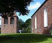 Village church, early 14th century
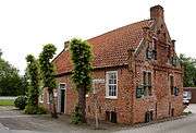 Former small castle, 15th century
References
Towns and municipalities in Aurich (district) | ||
|---|---|---|
This article is issued from Wikipedia - version of the 8/10/2016. The text is available under the Creative Commons Attribution/Share Alike but additional terms may apply for the media files.