Wilder, Tennessee
| Wilder, Tennessee | |
|---|---|
| Unincorporated community | |
|
Wilder Post Office in 2010 | |
 Wilder  Wilder | |
| Coordinates: 36°15′58″N 85°05′26″W / 36.26611°N 85.09056°WCoordinates: 36°15′58″N 85°05′26″W / 36.26611°N 85.09056°W | |
| Country | United States |
| State | Tennessee |
| County | Fentress |
| Elevation | 1,506 ft (459 m) |
| Time zone | Central (CST) (UTC-6) |
| • Summer (DST) | CDT (UTC-5) |
| ZIP Code | 38589 |
| Area code(s) | 931 |
| GNIS feature ID | 1274557[1] |

Wilder is an unincorporated community in Fentress County, Tennessee, United States. The town is in the Cumberland Mountains near Cookeville, Tennessee. It reached a population of more than 20,000 as a mining town in the 1920s, but had declined to an estimated population of 249 by 2013.
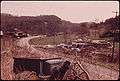 Abandoned cars in Wilder, 1974
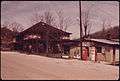 Flip Co-Op Store in Wilder, 1974
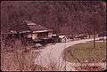 Old coal company store in Wilder, 1974
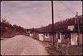 Wilder Post Office in 1974
References
- ↑ "US Board on Geographic Names". United States Geological Survey. Retrieved 4 January 2015.
Municipalities and communities of Fentress County, Tennessee, United States | ||
|---|---|---|
| Cities | ||
| CDPs | ||
| Unincorporated communities | ||
This article is issued from Wikipedia - version of the 8/17/2016. The text is available under the Creative Commons Attribution/Share Alike but additional terms may apply for the media files.