Verrua Savoia
| Verrua Savoia | ||
|---|---|---|
| Comune | ||
| Comune di Verrua Savoia | ||
|
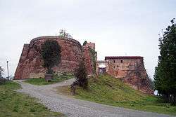
The fortress of Verrua. | ||
| ||
 Verrua Savoia Location of Verrua Savoia in Italy | ||
| Coordinates: 45°9′N 8°6′E / 45.150°N 8.100°ECoordinates: 45°9′N 8°6′E / 45.150°N 8.100°E | ||
| Country | Italy | |
| Region | Piedmont | |
| Province / Metropolitan city | Turin (TO) | |
| Government | ||
| • Mayor | Giuseppe Valesio | |
| Area | ||
| • Total | 31.9 km2 (12.3 sq mi) | |
| Population (Dec. 2004)[1] | ||
| • Total | 1,463 | |
| • Density | 46/km2 (120/sq mi) | |
| Demonym(s) | Verruesi | |
| Time zone | CET (UTC+1) | |
| • Summer (DST) | CEST (UTC+2) | |
| Postal code | 10020 | |
| Dialing code | 0161 | |
| Patron saint | St. John the Baptist | |
| Saint day | 24 June | |
| Website | Official website | |
Verrua Savoia is a comune (municipality) in the Province of Turin in the Italian region Piedmont, located about 35 kilometres (22 mi) northeast of Turin. The 18th-century San Giovanni Battista is a parish church in town.
References
External links
This article is issued from Wikipedia - version of the 10/8/2016. The text is available under the Creative Commons Attribution/Share Alike but additional terms may apply for the media files.