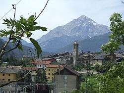
Salbertrand
| Salbertrand | |
|---|---|
| Comune | |
| Comune di Salbertrand | |
 | |
 Salbertrand Location of Salbertrand in Italy | |
| Coordinates: 45°4′20″N 6°53′3″E / 45.07222°N 6.88417°ECoordinates: 45°4′20″N 6°53′3″E / 45.07222°N 6.88417°E | |
| Country | Italy |
| Region | Piedmont |
| Province / Metropolitan city | Province of Turin (TO) |
| Area | |
| • Total | 40.9 km2 (15.8 sq mi) |
| Elevation | 1,032 m (3,386 ft) |
| Population (Dec. 2004) | |
| • Total | 522 |
| • Density | 13/km2 (33/sq mi) |
| Demonym(s) | Salbertrandesi |
| Time zone | CET (UTC+1) |
| • Summer (DST) | CEST (UTC+2) |
| Postal code | 10050 |
| Dialing code | 0122 |
| Website | Official website |
Salbertrand is a comune (municipality) in the Province of Turin in the Italian region Piedmont, about 60 km west of Turin. At 31 December 2004 it had a population of 522 and an area of 40.9 km².[1]
Salbertrand borders the following municipalities: Exilles, Oulx and Pragelato.
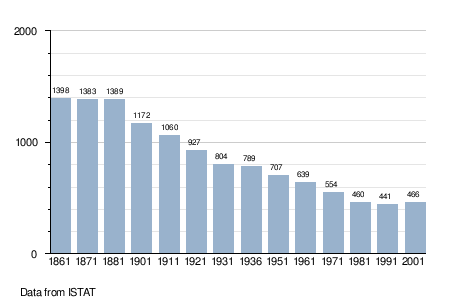
Population history
References
External links
This article is issued from Wikipedia - version of the 10/8/2016. The text is available under the Creative Commons Attribution/Share Alike but additional terms may apply for the media files.