Tome, New Mexico
| Tome, New Mexico | |
|---|---|
| Census-designated place | |
 Tome, New Mexico | |
| Coordinates: 34°44′27″N 106°43′42″W / 34.74083°N 106.72833°WCoordinates: 34°44′27″N 106°43′42″W / 34.74083°N 106.72833°W | |
| Country | United States |
| State | New Mexico |
| County | Valencia |
| Area[1] | |
| • Total | 4.948 sq mi (12.82 km2) |
| • Land | 4.948 sq mi (12.82 km2) |
| • Water | 0 sq mi (0 km2) |
| Elevation | 4,829 ft (1,472 m) |
| Population (2010)[2] | |
| • Total | 1,867 |
| • Density | 380/sq mi (150/km2) |
| Time zone | Mountain (MST) (UTC-7) |
| • Summer (DST) | MDT (UTC-6) |
| ZIP code | 87060 |
| Area code(s) | 505 |
| GNIS feature ID | 899958[3] |
Tome is a census-designated place in Valencia County, New Mexico, United States. Its population was 1,867 as of the 2010 census.[2] Tome has a post office with ZIP code 87060.[4][5] Prior to 2010, the community was part of the Tome-Adelino CDP.
References
- ↑ "US Gazetteer files: 2010, 2000, and 1990". United States Census Bureau. 2011-02-12. Retrieved 2011-04-23.
- 1 2 "American FactFinder". United States Census Bureau. Retrieved 2011-05-14.
- ↑ "Tome". Geographic Names Information System. United States Geological Survey.
- ↑ United States Postal Service (2012). "USPS - Look Up a ZIP Code". Retrieved 2012-02-15.
- ↑ "Postmaster Finder - Post Offices by ZIP Code". United States Postal Service. Retrieved August 18, 2013.
Municipalities and communities of Valencia County, New Mexico, United States | ||
|---|---|---|
| Cities | 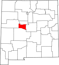 | |
| Town | ||
| Villages | ||
| CDPs |
| |
| Unincorporated communities | ||
This article is issued from Wikipedia - version of the 7/31/2014. The text is available under the Creative Commons Attribution/Share Alike but additional terms may apply for the media files.