Sun Valley, Arizona
Not to be confused with Star Valley, Arizona.
| Sun Valley, Arizona | |
|---|---|
| Unincorporated community | |
 Sun Valley, Arizona | |
| Coordinates: 34°58′50.09″N 110°3′29.43″W / 34.9805806°N 110.0581750°WCoordinates: 34°58′50.09″N 110°3′29.43″W / 34.9805806°N 110.0581750°W | |
| Country | United States |
| State | Arizona |
| County | Navajo |
| Elevation | 5,282 ft (1,610 m) |
| Population (2010[1]) | |
| • Total | 319 |
| Time zone | Mountain (MST) (UTC-7) |
| ZIP code | 86029 |
| Area code(s) | 928 |
| GNIS feature ID | 25324[2] |
Sun Valley is a populated place East of Holbrook, Arizona along Interstate 40. It is located at 34°58′50.09″N 110°3′29.43″W / 34.9805806°N 110.0581750°W in the Painted Desert and covers an area of 31.56 square miles.[3][4]
References
- ↑
- ↑ "US Board on Geographic Names". United States Geological Survey. 2007-10-25. Retrieved 2008-01-31.
- ↑ U.S. Geological Survey Geographic Names Information System
- ↑ arizona.hometownlocator.com
| Cities | 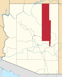 | |
|---|---|---|
| Towns | ||
| CDPs |
| |
| Unincorporated communities | ||
| Indian reservations |
| |
| Ghost towns | ||
| Footnotes | ‡This populated place also has portions in an adjacent county or counties | |
This article is issued from Wikipedia - version of the 7/31/2014. The text is available under the Creative Commons Attribution/Share Alike but additional terms may apply for the media files.