Sturgis, Oklahoma
| Sturgis, Oklahoma | |
|---|---|
| Unincorporated community | |
 Sturgis | |
| Coordinates: 36°53′38″N 102°04′13″W / 36.89389°N 102.07028°WCoordinates: 36°53′38″N 102°04′13″W / 36.89389°N 102.07028°W | |
| Country | United States |
| State | Oklahoma |
| County | Cimarron |
| Elevation | 3,773 ft (1,150 m) |
| Time zone | Central (CST) (UTC-6) |
| • Summer (DST) | CDT (UTC-5) |
| Area code(s) | 580 |
| GNIS feature ID | 1100860 |
Sturgis is an unincorporated community in northeastern Cimarron County, Oklahoma.[1] It is located on a railroad just north of U.S. Route 56.[2]
References
- ↑ U.S. Geological Survey Geographic Names Information System: Sturgis, Oklahoma
- ↑ 2007 Centennial State Map (Map). Oklahoma Department of Transportation. § C1.
Municipalities and communities of Cimarron County, Oklahoma, United States | ||
|---|---|---|
| City | 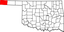 | |
| Town | ||
| CDPs | ||
| Other unincorporated communities | ||
This article is issued from Wikipedia - version of the 7/2/2015. The text is available under the Creative Commons Attribution/Share Alike but additional terms may apply for the media files.