Sari, Nepal
| Sari सारी | |
|---|---|
| Village Development Committee | |
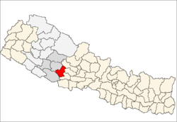
 Sari Location in Nepal | |
| Coordinates: 28°11′N 82°43′E / 28.19°N 82.71°ECoordinates: 28°11′N 82°43′E / 28.19°N 82.71°E | |
| Country |
|
| Region | Mid-Western |
| Zone | Rapti Zone |
| District | Pyuthan District |
| VDC | Sari |
| Population (2001 Census[1]) | |
| • Total | 3,590 |
| 727 households | |
| Time zone | Nepal Time (UTC+5:45) |
Sari is a town and Village Development Committee in Pyuthan, a Middle Hills district of Rapti Zone, western Nepal.
Villages in this VDC
| Ward | Lat. | Lon | Elev. | ||
|---|---|---|---|---|---|
| Dandagaun | डाँडागाउँ | 28°12'N | 82°43'E | 1,310m | |
| Danphedhara | डाँफेधारा | 28°12'N | 82°42'E | 1,190 | |
| Gaekharka | गाएखर्क | 28°11'N | 82°44'E | 990 | |
| Jholgaun | झोलगाउँ | 28°11'N | 82°43'E | 1,178 | |
| Kholakhet | खोलाखेत | 28°12'N | 82°42'E | 735 | |
| Maubari | मौबारी | 28°11'N | 82°42'E | 995 | |
| Saunepani | साउनेपानी | 28°12'N | 82°44'E | 1,690 | |
| Sisneri | सिस्नेरी | 28°12'N | 82°44'E | 1,850 | |
| Syani lekh | स्यानी लेख | 8 | 28°11'N | 82°44'E | 1,510 |
| Tahar Dhik | टाहार ढिक | 28°11'N | 82°42'E | 745 | |
| Takura | टाकुरा | 28°10'N | 82°43'E | 785 | |
| Talla Sari | तल्ला सारी | 28°11'N | 82°43'E | 756 | |
| Upalla sari | उपल्ला सारी | 28°11'N | 82°42'E | 810 |
References
- ↑ "Nepal Census 2001". Nepal's Village Development Committees. Digital Himalaya. Retrieved 21 September 2008.
- ↑ "Index of Geographical Names of Nepal, Volume IV: Mid Western Development Region, List of Settlements, Pyuthan" (PDF). Government of Nepal, National Geographic Information Infrastructure Program. Retrieved 2011-03-12.
External links
This article is issued from Wikipedia - version of the 2/21/2015. The text is available under the Creative Commons Attribution/Share Alike but additional terms may apply for the media files.