Rye, Arkansas
| Rye, Arkansas | |
|---|---|
| Census-designated place | |
 Rye | |
| Coordinates: 33°44′46″N 91°59′52″W / 33.74611°N 91.99778°WCoordinates: 33°44′46″N 91°59′52″W / 33.74611°N 91.99778°W | |
| Country | United States |
| State | Arkansas |
| County | Cleveland |
| Area[1] | |
| • Total | 4.364 sq mi (11.30 km2) |
| • Land | 4.364 sq mi (11.30 km2) |
| • Water | 0 sq mi (0 km2) |
| Elevation | 187 ft (57 m) |
| Population (2010)[2] | |
| • Total | 146 |
| • Density | 33/sq mi (13/km2) |
| Time zone | Central (CST) (UTC-6) |
| • Summer (DST) | CDT (UTC-5) |
| Area code(s) | 870 |
| GNIS feature ID | 57175[3] |
Rye is a census-designated place in Cleveland County, Arkansas, United States. Its population was 146 as of the 2010 census.[2]
Education
Public education for elementary and secondary students is available from the Woodlawn School District, which leads to graduation from Woodlawn High School.
References
- ↑ "US Gazetteer files: 2010, 2000, and 1990". United States Census Bureau. 2011-02-12. Retrieved 2011-04-23.
- 1 2 "Geographic Identifiers: 2010 Demographic Profile Data (G001): Rye CDP, Arkansas". U.S. Census Bureau, American Factfinder. Retrieved June 17, 2014.
- ↑ U.S. Geological Survey Geographic Names Information System: Rye, Arkansas
Municipalities and communities of Cleveland County, Arkansas, United States | ||
|---|---|---|
| Cities | 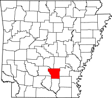 | |
| CDPs | ||
| Unincorporated communities | ||
This article is issued from Wikipedia - version of the 10/9/2014. The text is available under the Creative Commons Attribution/Share Alike but additional terms may apply for the media files.