Rupt-aux-Nonains
| Rupt-aux-Nonains | |
|---|---|
 | |
 Rupt-aux-Nonains | |
|
Location within Grand Est region  Rupt-aux-Nonains | |
| Coordinates: 48°40′18″N 5°06′53″E / 48.6717°N 5.1147°ECoordinates: 48°40′18″N 5°06′53″E / 48.6717°N 5.1147°E | |
| Country | France |
| Region | Grand Est |
| Department | Meuse |
| Arrondissement | Arrondissement of Bar-le-Duc |
| Canton | Canton of Ancerville |
| Intercommunality | Communauté de communes des Pays de la Saulx et du Perthois |
| Government | |
| • Mayor (2008–2014) | Yannik Intins |
| Area1 | 20.4 km2 (7.9 sq mi) |
| Population (1999)2 | 353 |
| • Density | 17/km2 (45/sq mi) |
| Time zone | CET (UTC+1) |
| • Summer (DST) | CEST (UTC+2) |
| INSEE/Postal code | 55447 / 55170 |
| Elevation |
173–271 m (568–889 ft) (avg. 190 m or 620 ft) |
|
1 French Land Register data, which excludes lakes, ponds, glaciers > 1 km² (0.386 sq mi or 247 acres) and river estuaries. 2 Population without double counting: residents of multiple communes (e.g., students and military personnel) only counted once. | |
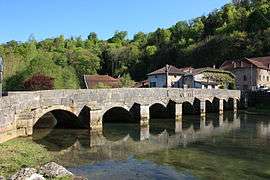
Rupt-aux-Nonains is a commune in the Meuse department in Grand Est in north-eastern France. It lies on the Saulx, which is crossed here by the bridge, carrying the date 1557, that is the commune's most notable feature.
See also
| Wikimedia Commons has media related to Rupt-aux-Nonains. |
This article is issued from Wikipedia - version of the 11/6/2016. The text is available under the Creative Commons Attribution/Share Alike but additional terms may apply for the media files.