Rivière-à-Claude, Quebec
| Rivière-à-Claude | |
|---|---|
| Municipality | |
 | |
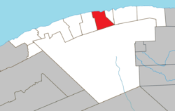 Location within La Haute-Gaspésie RCM. | |
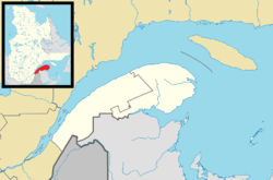 Rivière-à-Claude Location in eastern Quebec. | |
| Coordinates: 49°13′N 65°54′W / 49.217°N 65.900°WCoordinates: 49°13′N 65°54′W / 49.217°N 65.900°W[1] | |
| Country |
|
| Province |
|
| Region | Gaspésie–Îles-de-la-Madeleine |
| RCM | La Haute-Gaspésie |
| Settled | 1860 |
| Constituted | December 18, 1923 |
| Government[2] | |
| • Mayor | Réjean Normand |
| • Federal riding |
Haute-Gaspésie—La Mitis—Matane—Matapédia |
| • Prov. riding | Gaspé |
| Area[2][3] | |
| • Total | 153.70 km2 (59.34 sq mi) |
| • Land | 156.61 km2 (60.47 sq mi) |
|
There is an apparent contradiction between two authoritative sources | |
| Population (2011)[3] | |
| • Total | 130 |
| • Density | 0.8/km2 (2/sq mi) |
| • Pop 2006-2011 |
|
| • Dwellings | 127 |
| Time zone | EST (UTC−5) |
| • Summer (DST) | EDT (UTC−4) |
| Postal code(s) | G0E 1Z0 |
| Area code(s) | 418 and 581 |
| Highways |
|
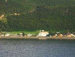
Rivière-à-Claude is a municipality in the Gaspésie-Îles-de-la-Madeleine region of the province of Quebec in Canada.
In addition to Rivière-à-Claude itself, the municipality also includes the community of Ruisseau-à-Rebours.
History
The first permanent settlers arrived in 1860. The settlement, originally called Duchesnay after senator Édouard-Louis-Antoine-Charles Juchereau Duchesnay (1809-1886), gained a post office in 1879 and grew to 200 persons by 1888. In 1898, the Parish of Saint-Évagre was founded.[1]
In 1923, the place was incorporated. In 1968, the municipality was renamed to Rivière-à-Claude after the Claude River that has its source near the municipality's inland boundary. This river may be named in honour of a pioneer named Joseph Glaude, but there is no certainty since various spellings have existed over time.[1]
Demographics
Population
| Canada census – Rivière-à-Claude, Quebec community profile | |||
|---|---|---|---|
| 2011 | 2006 | 2001 | |
| Population: | 130 (-24.0% from 2006) | 171 (+6.2% from 2001) | 161 (-16.1% from 1996) |
| Land area: | 156.61 km2 (60.47 sq mi) | 156.61 km2 (60.47 sq mi) | 156.61 km2 (60.47 sq mi) |
| Population density: | 0.8/km2 (2.1/sq mi) | 1.1/km2 (2.8/sq mi) | 1.0/km2 (2.6/sq mi) |
| Median age: | 58.5 (M: 55.8, F: 60.8) | 54.1 (M: 51.5, F: 55.5) | 57.5 (M: 59.3, F: 56.8) |
| Total private dwellings: | 127 | 109 | 129 |
| Median household income: | $.N/A | $.N/A | $.N/A |
| Notes: Income data for this area has been suppressed for data quality or confidentiality reasons. – References: 2011[3] 2006[4] 2001[5] | |||
| Historical Census Data - Rivière-à-Claude, Quebec[6] | ||||||||||||||||||||||||||
|---|---|---|---|---|---|---|---|---|---|---|---|---|---|---|---|---|---|---|---|---|---|---|---|---|---|---|
|
|
| ||||||||||||||||||||||||
See also
References
- 1 2 3 "Rivière-à-Claude (Municipalité)" (in French). Commission de toponymie du Québec. Retrieved 2011-12-15.
- 1 2 "Rivière-à-Claude". Répertoire des municipalités (in French). Ministère des Affaires municipales, des Régions et de l'Occupation du territoire. Retrieved 2011-12-15.
- 1 2 3 "Rivière-à-Claude census profile". 2011 Census data. Statistics Canada. Retrieved 2011-12-15.
- ↑ "2006 Community Profiles". Canada 2006 Census. Statistics Canada. March 30, 2011. Retrieved 2011-12-15.
- ↑ "2001 Community Profiles". Canada 2001 Census. Statistics Canada. February 17, 2012. Retrieved 2011-12-15.
- ↑ Statistics Canada: 1996, 2001, 2006, 2011 census
 |
Gulf of Saint Lawrence | | ||
| Marsoui | |
Mont-Saint-Pierre | ||
| ||||
| | ||||
| Mont-Albert |
| Cities | |
|---|---|
| Municipalities | |
| Villages | |
| Unorganized Territories | |
| |