Redland, Texas
| Redland, Texas | |
|---|---|
| Census-designated place | |
|
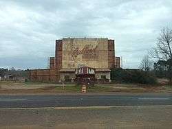
Abandoned Redland Drive In Movie Theater in Redland, Texas | |
 Redland | |
| Coordinates: 31°24′37″N 94°43′30″W / 31.41028°N 94.72500°WCoordinates: 31°24′37″N 94°43′30″W / 31.41028°N 94.72500°W | |
| Country | United States |
| State | Texas |
| County | Angelina |
| Area | |
| • Total | 4.15 sq mi (10.74 km2) |
| • Land | 4.12 sq mi (10.68 km2) |
| • Water | 0.03 sq mi (0.07 km2) |
| Elevation | 355 ft (108 m) |
| Population (2010) | |
| • Total | 1,047 |
| • Density | 254/sq mi (98.1/km2) |
| Time zone | Central (CST) (UTC-6) |
| • Summer (DST) | CDT (UTC-5) |
| Area code(s) | 936 |
| FIPS code | 48-61124 |
| GNIS feature ID | 1382608 |
Redland is an unincorporated town and census-designated place (CDP) in Angelina County, Texas, United States. The population was 1,047 at the 2010 census.[1]
Geography
Redland is located in northern Angelina County 6 miles (10 km) north of the center of Lufkin, the county seat. U.S. Route 59, a four-lane highway, runs through the CDP, leading south to Lufkin and north 14 miles (23 km) to Nacogdoches.
According to the United States Census Bureau, the CDP has a total area of 4.1 square miles (10.7 km2), of which 0.03 square miles (0.07 km2), or 0.62%, is water.[1]
References
- 1 2 "Geographic Identifiers: 2010 Demographic Profile Data (G001): Redland CDP, Texas". U.S. Census Bureau, American Factfinder. Retrieved August 9, 2013.
External links
- Redland, TX (Angelina County) from the Handbook of Texas Online
Municipalities and communities of Angelina County, Texas, United States | ||
|---|---|---|
| Cities | 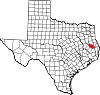 | |
| CDP | ||
| Other unincorporated communities | ||
This article is issued from Wikipedia - version of the 7/14/2015. The text is available under the Creative Commons Attribution/Share Alike but additional terms may apply for the media files.