R678 road (Ireland)
| |
|---|---|
|
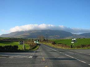
Ballyhest Crossroads, where the R678 and R676 meet. | |
| Route information | |
| Length: | 30.9 km (19.2 mi) |
| Major junctions | |
| From: |
|
|
Enters County Waterford Passes through Rathgormack Crosses River Clodiagh | |
| To: |
|
| Road network | |
The R678 road is a regional road in Ireland, located in County Tipperary and County Waterford.[1][2]
References
- ↑ "R678 - Roader's Digest: The SABRE Wiki". sabre-roads.org.uk. Retrieved 2016-03-09.
- ↑ "S.I. No. 54/2012 - Roads Act 1993 (Classification of Regional Roads) Order 2012.". irishstatutebook.ie. Retrieved 2016-03-09.
Coordinates: 52°17′31″N 7°27′56″W / 52.291992°N 7.465606°W
This article is issued from Wikipedia - version of the 3/14/2016. The text is available under the Creative Commons Attribution/Share Alike but additional terms may apply for the media files.