Röthlein
| Röthlein | ||
|---|---|---|
|
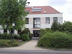
Röthlein Rathaus, or Town Hall | ||
| ||
 Röthlein | ||
Location of Röthlein within Schweinfurt district 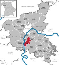 | ||
| Coordinates: 49°58′N 10°13′E / 49.967°N 10.217°ECoordinates: 49°58′N 10°13′E / 49.967°N 10.217°E | ||
| Country | Germany | |
| State | Bavaria | |
| Admin. region | Unterfranken | |
| District | Schweinfurt | |
| Government | ||
| • Mayor | Edgar Engelbrecht (CSU/FWG) | |
| Area | ||
| • Total | 19.09 km2 (7.37 sq mi) | |
| Population (2015-12-31)[1] | ||
| • Total | 4,561 | |
| • Density | 240/km2 (620/sq mi) | |
| Time zone | CET/CEST (UTC+1/+2) | |
| Postal codes | 97520 | |
| Dialling codes | 09723 | |
| Vehicle registration | SW | |
| Website | www.roethlein.de | |

Röthlein is a municipality in the district of Schweinfurt in Bavaria, Germany. The village is located south of Schweinfurt, close to the Main valley. The quarters are Röthlein, Heidenfeld and Hirschfeld.
References
- ↑ "Fortschreibung des Bevölkerungsstandes". Bayerisches Landesamt für Statistik und Datenverarbeitung (in German). June 2016.
This article is issued from Wikipedia - version of the 7/24/2016. The text is available under the Creative Commons Attribution/Share Alike but additional terms may apply for the media files.