Puy-Sanières
| Puy-Sanières | ||
|---|---|---|
|
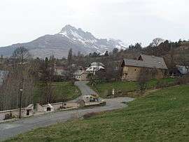
A partial view of the village of Puy-Sanières | ||
| ||
 Puy-Sanières | ||
|
Location within Provence-A.-C.d'A. region 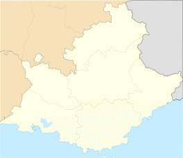 Puy-Sanières | ||
| Coordinates: 44°33′32″N 6°26′06″E / 44.5589°N 6.435°ECoordinates: 44°33′32″N 6°26′06″E / 44.5589°N 6.435°E | ||
| Country | France | |
| Region | Provence-Alpes-Côte d'Azur | |
| Department | Hautes-Alpes | |
| Arrondissement | Gap | |
| Canton | Savines-le-Lac | |
| Intercommunality | Savinois–Serre Ponçon | |
| Government | ||
| • Mayor (2008–2014) | Valérie Rossi | |
| Area1 | 11.38 km2 (4.39 sq mi) | |
| Population (208)2 | 220 | |
| • Density | 19/km2 (50/sq mi) | |
| Time zone | CET (UTC+1) | |
| • Summer (DST) | CEST (UTC+2) | |
| INSEE/Postal code | 05111 / 05200 | |
| Elevation |
780–2,524 m (2,559–8,281 ft) (avg. 1,125 m or 3,691 ft) | |
|
1 French Land Register data, which excludes lakes, ponds, glaciers > 1 km² (0.386 sq mi or 247 acres) and river estuaries. 2 Population without double counting: residents of multiple communes (e.g., students and military personnel) only counted once. | ||

Puy-Sanières is a commune in the Hautes-Alpes department in southeastern France.
Population
| Historical population | ||
|---|---|---|
| Year | Pop. | ±% |
| 1962 | 42 | — |
| 1968 | 78 | +85.7% |
| 1975 | 66 | −15.4% |
| 1982 | 31 | −53.0% |
| 1990 | 106 | +241.9% |
| 1999 | 155 | +46.2% |
| 2008 | 220 | +41.9% |
See also
References
| Wikimedia Commons has media related to Puy-Sanières. |
This article is issued from Wikipedia - version of the 2/12/2016. The text is available under the Creative Commons Attribution/Share Alike but additional terms may apply for the media files.