Prelà
| Prelà | |
|---|---|
| Comune | |
| Comune di Prelà | |
|
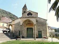
San Giovanni del Grappo Church | |
 Prelà Location of Prelà in Italy | |
| Coordinates: 43°56′N 7°57′E / 43.933°N 7.950°ECoordinates: 43°56′N 7°57′E / 43.933°N 7.950°E | |
| Country | Italy |
| Region | Liguria |
| Province / Metropolitan city | Province of Imperia (IM) |
| Area | |
| • Total | 15.4 km2 (5.9 sq mi) |
| Population (Dec. 2004) | |
| • Total | 497 |
| • Density | 32/km2 (84/sq mi) |
| Time zone | CET (UTC+1) |
| • Summer (DST) | CEST (UTC+2) |
| Postal code | 18020 |
| Dialing code | 0196 |
Prelà is a comune (municipality) in the Province of Imperia in the Italian region Liguria, located about 100 kilometres (62 mi) southwest of Genoa and about 9 kilometres (6 mi) northwest of Imperia. As of 31 December 2004, it had a population of 497 and an area of 15.4 square kilometres (5.9 sq mi).[1]
Prelà borders the following municipalities: Borgomaro, Carpasio, Dolcedo, Montalto Ligure, and Vasia.
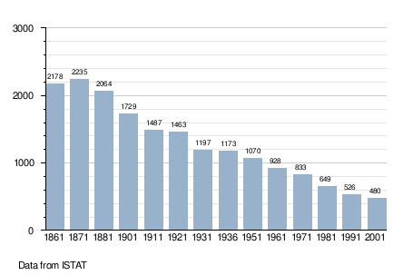
Demographic evolution
Twin towns — Sister cities
Prelà is twinned with:
-
 Châteauneuf-Grasse, France (2005)
References
This article is issued from Wikipedia - version of the 2/12/2015. The text is available under the Creative Commons Attribution/Share Alike but additional terms may apply for the media files.