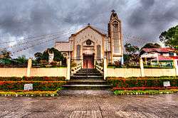
Pintuyan, Southern Leyte
| Pintuyan | |
|---|---|
| Municipality | |
 | |
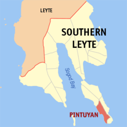 Map of Southern Leyte with Pintuyan highlighted | |
.svg.png) Pintuyan Location within the Philippines | |
| Coordinates: 09°57′N 125°15′E / 9.950°N 125.250°ECoordinates: 09°57′N 125°15′E / 9.950°N 125.250°E | |
| Country | Philippines |
| Region | Eastern Visayas (Region VIII) |
| Province | Southern Leyte |
| Congr. district | Lone district of S. Leyte |
| Barangays | 23 |
| Government[1] | |
| • Mayor | Celsa A. Estrella |
| Area[2] | |
| • Total | 36.98 km2 (14.28 sq mi) |
| Population (2010)[3] | |
| • Total | 9,261 |
| • Density | 250/km2 (650/sq mi) |
| Time zone | PST (UTC+8) |
| ZIP code | 6614 |
| Dialing code | 53 |
Pintuyan is a fifth class municipality in the province of Southern Leyte, Philippines. According to the 2010 census, it has a population of 9,261 people.[3]
Barangays
Pintuyan is politically subdivided into 23 barangays.[2]
- Badiang
- Balongbalong
- Buenavista
- Bulawan
- Canlawis
- Catbawan
- Caubang
- Cogon
- Dan-an
- Lobo
- Mainit
- Manglit
- Nueva Estrella Sur
- Poblacion Ibabao
- Poblacion Ubos
- Ponod
- Son-ok I
- Tautag
- Nueva Estrella Norte
- Ponciano D. Equipilag
- San Roque
- Santa Cruz
- Son-ok II
Demographics
| Population census of Pintuyan | ||
|---|---|---|
| Year | Pop. | ±% p.a. |
| 1990 | 8,177 | — |
| 1995 | 8,388 | +0.48% |
| 2000 | 9,567 | +2.86% |
| 2007 | 9,911 | +0.49% |
| 2010 | 9,261 | −2.44% |
| Source: National Statistics Office[3] | ||
References
- ↑ "Municipalities". Quezon City, Philippines: Department of the Interior and Local Government. Retrieved 15 July 2013.
- 1 2 "Province: Southern Leyte". PSGC Interactive. Makati City, Philippines: National Statistical Coordination Board. Retrieved 15 July 2013.
- 1 2 3 "Total Population by Province, City, Municipality and Barangay: as of May 1, 2010" (PDF). 2010 Census of Population and Housing. National Statistics Office. Retrieved 15 July 2013.
External links
- Philippine Standard Geographic Code
- Philippine Census Information
- Local Governance Performance Management System
 |
San Francisco | | ||
| Limasawa / Bohol Sea | |
San Ricardo | ||
| ||||
| | ||||
| Bohol Sea |
This article is issued from Wikipedia - version of the 8/10/2016. The text is available under the Creative Commons Attribution/Share Alike but additional terms may apply for the media files.