Penrod, Kentucky
| Penrod | |
|---|---|
| Unincorporated community | |
 Penrod  Penrod Location within the state of Kentucky | |
| Coordinates: 37°6′51″N 86°59′57″W / 37.11417°N 86.99917°WCoordinates: 37°6′51″N 86°59′57″W / 37.11417°N 86.99917°W | |
| Country | United States |
| State | Kentucky |
| County | Muhlenberg |
| Elevation | 433 ft (132 m) |
| Time zone | Central (CDT) (UTC-5) |
| • Summer (DST) | EDT (UTC-4) |
| ZIP codes | 42365 |
| GNIS feature ID | 500395[1] |
Penrod is an unincorporated community in Muhlenberg County, Kentucky, United States.
History
A post office called Penrod was established in 1885, and remained in operation until 1994.[2] H. C. Penrod, an early postmaster, gave the community his name.[3]
References
- ↑ U.S. Geological Survey Geographic Names Information System: Penrod, Kentucky
- ↑ "Muhlenberg County". Jim Forte Postal History. Retrieved 16 April 2015.
- ↑ Anderson, Bobby (Sep 19, 2007). "Sandy Called These Names". Leader-News. pp. A12. Retrieved 16 May 2015.
Municipalities and communities of Muhlenberg County, Kentucky, United States | ||
|---|---|---|
| Cities | 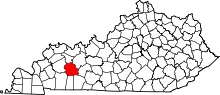 | |
| CDPs | ||
| Unincorporated communities | ||
| Ghost town | ||
| Footnotes | ‡This populated place also has portions in an adjacent county or counties | |
This article is issued from Wikipedia - version of the 7/27/2016. The text is available under the Creative Commons Attribution/Share Alike but additional terms may apply for the media files.