Pauley, Kentucky
| Pauley | |
|---|---|
| Unincorporated community | |
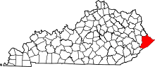
 Pauley  Pauley Location within the state of Kentucky | |
| Coordinates: 37°29′41″N 82°32′7″W / 37.49472°N 82.53528°WCoordinates: 37°29′41″N 82°32′7″W / 37.49472°N 82.53528°W | |
| Country | United States |
| State | Kentucky |
| County | Pike |
| Elevation | 656 ft (200 m) |
| Time zone | Central (CST) (UTC-6) |
| • Summer (DST) | CST (UTC-5) |
| GNIS feature ID | 500273[1] |
Pauley is an unincorporated community and coal town in Pike County, Kentucky, United States. Their post office [2] is closed. It was also known as Panley.
References
This article is issued from Wikipedia - version of the 7/27/2016. The text is available under the Creative Commons Attribution/Share Alike but additional terms may apply for the media files.