Namekagon, Wisconsin
| Namekagon, Wisconsin | |
|---|---|
| Unincorporated community | |
 Namekagon  Namekagon | |
| Coordinates: 46°12′46″N 91°02′44″W / 46.21278°N 91.04556°WCoordinates: 46°12′46″N 91°02′44″W / 46.21278°N 91.04556°W | |
| Country | United States |
| State | Wisconsin |
| County | Bayfield |
| Town | Namakagon |
| Elevation | 1,404 ft (428 m) |
| Time zone | Central (CST) (UTC-6) |
| • Summer (DST) | CDT (UTC-5) |
| Area code(s) | 715 and 534 |
| GNIS feature ID | 1579987[1] |
Namekagon is an unincorporated community in the town of Namakagon, Bayfield County, Wisconsin, United States. Namekagon is located on the eastern shore of Garden Lake; it is 7.5 miles (12.1 km) west-northwest of Clam Lake, 25 miles (40 km) northeast of Hayward, and 27 miles (43 km) south-southwest of Ashland.
References
Municipalities and communities of Bayfield County, Wisconsin, United States | ||
|---|---|---|
| Cities | 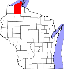 | |
| Village | ||
| Towns | ||
| CDPs | ||
| Unincorporated communities | ||
| Indian reservation | ||
| Footnotes | ‡This populated place also has portions in an adjacent county or counties | |
This article is issued from Wikipedia - version of the 7/29/2016. The text is available under the Creative Commons Attribution/Share Alike but additional terms may apply for the media files.