Mills, Utah
| Mills, Utah | |
|---|---|
| Unincorporated community | |
 Mills, Utah  Mills, Utah | |
| Coordinates: 39°28′58″N 112°01′41″W / 39.48278°N 112.02806°WCoordinates: 39°28′58″N 112°01′41″W / 39.48278°N 112.02806°W | |
| Country | United States |
| State | Utah |
| County | Juab |
| Elevation | 4,954 ft (1,510 m) |
| Time zone | Mountain (MST) (UTC-7) |
| • Summer (DST) | MDT (UTC-6) |
| Area code(s) | 435 |
| GNIS feature ID | 1430350[1] |
Mills is an unincorporated community located in Juab County, Utah, United States.[1][2] The cemetery and few building remnants remain.
History
Settled as a railroad town, it was also known as Wellington in the mid to late 1800s. Many residents lived in dugouts or cabins. There was a local general store owned by John Williams, who lived nearby. John Williams Canyon was named after Williams.[3]
References
- 1 2 "Mills, Utah". Geographic Names Information System. United States Geological Survey.
- ↑ Markosian, Richard (June 30, 2010). "Mills, Utah: "A nice quiet place to live"". Utah Stories. Retrieved July 16, 2013.
- ↑ Ghost towns-Mills, Utah
Municipalities and communities of Juab County, Utah, United States | ||
|---|---|---|
| Cities | 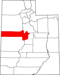 | |
| Towns | ||
| Unincorporated communities | ||
| Ghost towns | ||
| Footnotes | ‡This populated place also has portions in an adjacent county or counties | |
This article is issued from Wikipedia - version of the 8/8/2016. The text is available under the Creative Commons Attribution/Share Alike but additional terms may apply for the media files.