Michopdo, California
Coordinates: 39°43′55″N 121°51′14″W / 39.73194°N 121.85389°W
| Michopdo | |
|---|---|
| Former settlement | |
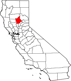
 Michopdo Location in California | |
| Coordinates: 39°43′55″N 121°51′14″W / 39.73194°N 121.85389°W | |
| Country | United States |
| State | California |
| County | Butte County |
| Elevation[1] | 187 ft (57 m) |
Michopdo (also, Ma-chuc-na, Ma-chuck-nas, Mich-op-do, Michoapdos, Mitshopda, and Wachuknas) is a former Maidu settlement in Butte County, California. It lay at an elevation of 187 feet (57 m).
References
External links
This article is issued from Wikipedia - version of the 7/14/2016. The text is available under the Creative Commons Attribution/Share Alike but additional terms may apply for the media files.