Mamba, Tibet
| Mamba | |
|---|---|
| Township | |
| Tibetan transcription(s) | |
| Chinese transcription(s) | |
| • Traditional | 门巴乡 |
|
View from Drigung Monastery | |
 Mamba | |
| Coordinates: 30°06′12″N 92°12′54″E / 30.10333°N 92.21500°ECoordinates: 30°06′12″N 92°12′54″E / 30.10333°N 92.21500°E | |
| Country | China |
| Province | Tibet Autonomous Region |
| Prefecture | Lhasa Prefecture |
| County | Maizhokunggar County |
| Area | |
| • Total | 822 km2 (317 sq mi) |
| Population | |
| • Total | 2,900 |
| Time zone | CST (UTC+8) |
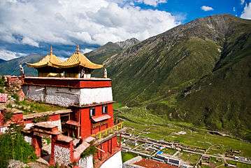
Mamba (门巴乡) is a small town and township-level division in Lhasa prefecture-level city in Maizhokunggar County in the Tibet Autonomous Region of China. Administratively it is divided into six village-level divisional units, and the township covers an area of 822 square kilometres (317 sq mi), with a population of about 2,900. Animal husbandry, with the rearing of yak, sheep, goats, and agriculture, with the principal crops being barley, wheat, and canola, is predominant.[1] Geologically, Late Triassic granitoids in the area are mainly "exposed in a fault uplift in the Gangdise tectonic belt".[2] The township is home to Drigung Monastery.
See also
References
- ↑ "门巴乡" (in Chinese). Baidu Baike encyclopedia. Retrieved 27 February 2015.
- ↑ 地質通報. 中國學術期刊 (光盤版) 電子雜誌社. 2005. p. 235.
This article is issued from Wikipedia - version of the 10/23/2016. The text is available under the Creative Commons Attribution/Share Alike but additional terms may apply for the media files.