Maharajganj, Nepal
For other places with the same name, see Mahrajganj.
| Maharajganj महाराजगञ्ज Maharijgha | |
|---|---|
| Village development committee | |
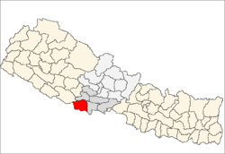
 Maharajganj Location in Nepal | |
| Coordinates: 27°34′N 82°58′E / 27.56°N 82.97°ECoordinates: 27°34′N 82°58′E / 27.56°N 82.97°E | |
| Country |
|
| Zone | Lumbini Zone |
| District | Kapilvastu District |
| Population (1991) | |
| • Total | 4,590 |
| Time zone | Nepal Time (UTC+5:45) |
Maharajganj is a village development committee in Kapilvastu District in the Lumbini Zone of southern Nepal. At the time of the 1991 Nepal census it had a population of 10,454 people living in 1779 individual households.[1] A small flood in 1993 ruined a marginal amount of cropland.
References
- ↑ "Nepal Census 2001". Nepal's Village Development Committees. Digital Himalaya. Retrieved 14 December 2008.
This article is issued from Wikipedia - version of the 10/20/2014. The text is available under the Creative Commons Attribution/Share Alike but additional terms may apply for the media files.