Mace, Indiana
| Mace | |
|---|---|
| Unincorporated community | |
|
Corner of Main Street and 600 East on the east side of Mace. | |
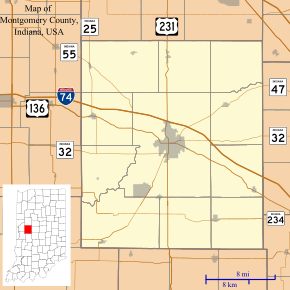 Mace Location in Montgomery County | |
| Coordinates: 40°00′37″N 86°47′47″W / 40.01028°N 86.79639°WCoordinates: 40°00′37″N 86°47′47″W / 40.01028°N 86.79639°W | |
| Country | United States |
| State | Indiana |
| County | Montgomery |
| Township | Walnut |
| Elevation | 840 ft (260 m) |
| ZIP code | 47933 |
| FIPS code | 18-45720[1] |
| GNIS feature ID | 438449[2] |

Mace is an unincorporated community in Walnut Township, Montgomery County, Indiana.
History
Mace, formerly called Fredericksburg, was laid out in about 1840 by Frederick Long.[3]
Geography
Mace is located at 40°00′37″N 86°47′47″W / 40.01028°N 86.79639°W.
References
- ↑ "American FactFinder". United States Census Bureau. Retrieved 2008-01-31.
- ↑ "Mace, Indiana". Geographic Names Information System. United States Geological Survey. Retrieved 2009-10-17.
- ↑ Beckwith, Hiram Williams & Kennedy, P. S. (1881). History of Montgomery County, Together with Historic Notes on the Wabash Valley. H. H. Hill and N. Iddings. p. 372.
Gallery
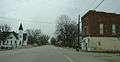 Looking east along U.S. Route 136 into Mace
 Mace Cemetery
Municipalities and communities of Montgomery County, Indiana, United States | ||
|---|---|---|
| City | ||
| Towns | ||
| Townships | ||
| CDP | ||
| Other unincorporated communities |
| |
This article is issued from Wikipedia - version of the 10/12/2016. The text is available under the Creative Commons Attribution/Share Alike but additional terms may apply for the media files.