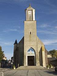
La Loupe
| La Loupe | ||
|---|---|---|
 | ||
| ||
 La Loupe | ||
|
Location within Centre-Val de Loire region 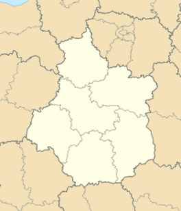 La Loupe | ||
| Coordinates: 48°28′21″N 1°00′57″E / 48.4725°N 1.0158°ECoordinates: 48°28′21″N 1°00′57″E / 48.4725°N 1.0158°E | ||
| Country | France | |
| Region | Centre-Val de Loire | |
| Department | Eure-et-Loir | |
| Arrondissement | Nogent-le-Rotrou | |
| Canton | La Loupe | |
| Intercommunality | Portes du Perche | |
| Government | ||
| • Mayor (2008–2014) | Eric Gérard | |
| Area1 | 7.27 km2 (2.81 sq mi) | |
| Population (2008)2 | 3,465 | |
| • Density | 480/km2 (1,200/sq mi) | |
| Time zone | CET (UTC+1) | |
| • Summer (DST) | CEST (UTC+2) | |
| INSEE/Postal code | 28214 / 28240 | |
| Elevation | 192–243 m (630–797 ft) | |
|
1 French Land Register data, which excludes lakes, ponds, glaciers > 1 km² (0.386 sq mi or 247 acres) and river estuaries. 2 Population without double counting: residents of multiple communes (e.g., students and military personnel) only counted once. | ||

La Loupe is a commune in the Eure-et-Loir department in northern France.
Population
| Historical population | ||
|---|---|---|
| Year | Pop. | ±% |
| 1962 | 2,737 | — |
| 1968 | 3,510 | +28.2% |
| 1975 | 3,719 | +6.0% |
| 1982 | 3,693 | −0.7% |
| 1990 | 3,820 | +3.4% |
| 1999 | 3,734 | −2.3% |
| 2008 | 3,465 | −7.2% |
Sister city
Royston in Hertfordshire, England
See also
References
| Wikimedia Commons has media related to La Loupe. |
This article is issued from Wikipedia - version of the 6/21/2015. The text is available under the Creative Commons Attribution/Share Alike but additional terms may apply for the media files.