Mount Kusatsu-Shirane
| Mount Kusatsu-Shirane | |
|---|---|
| 草津白根山 | |
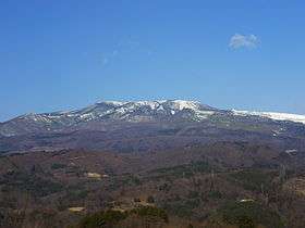 Viewed from the SE. | |
| Highest point | |
| Elevation | 2,171 m (7,123 ft) |
| Coordinates | 36°37′12″N 138°32′06″E / 36.620°N 138.535°E |
| Geography | |
| Location | Honshū, Japan |
| Geology | |
| Mountain type | Stratovolcanoes |
| Last eruption | July to December 1983 |
Mount Kusatsu-Shirane (草津白根山 Kusatsu Shirane-san) is a 2160-meter active volcano in Kusatsu, Gunma, Japan. It is called Kusatsu Shirane to differentiate it from the Mount Nikkō-Shirane on the other side of Gunma Prefecture. The summit of Kusatsu-Shirane volcano, located immediately north of Asama volcano, consists of a series of overlapping pyroclastic cones and three crater lakes. The largest of these is Yu-gama, an acidic turquoise-colored lake with rafts of yellow sulfur floating on its surface.
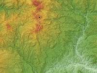 Relief Map of Kusatsu-Shirane Volcano
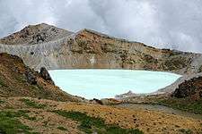 Famous Yugama crater
See also
References
External links
| Wikimedia Commons has media related to Mount Kusatsu-Shirane. |
- Kusatsu-Shiranesan - Japan Meteorological Agency (Japanese)
- "Kusatsu-Shiranesan: National catalogue of the active volcanoes in Japan" (PDF). - Japan Meteorological Agency
- Kusatsu-Shirane Volcano - Geological Survey of Japan
- Kusatsu-Shiranesan - Smithsonian Institution: Global Volcanism Program
This article is issued from Wikipedia - version of the 11/17/2016. The text is available under the Creative Commons Attribution/Share Alike but additional terms may apply for the media files.