Kolokythas
| Native name: Κολοκύθας | |
|---|---|
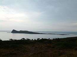 The islet of Kolokythas. | |
 Kolokythas | |
| Geography | |
| Coordinates | 35°15′50″N 25°45′36″E / 35.264°N 25.760°ECoordinates: 35°15′50″N 25°45′36″E / 35.264°N 25.760°E |
| Archipelago | Cretan Islands |
| Area | 0.144 km2 (0.056 sq mi) |
| Administration | |
|
Greece | |
| Region | Crete |
| Regional unit | Lasithi |
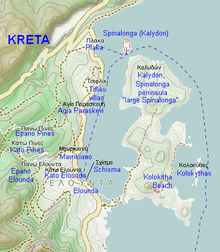
Map of Elounda, Spinalonga and surrounding areas.
Kolokythas (Greek: Κολοκύθας "pumpkin", also known as Κολοκυθιά, Kolokythia and Βρυονήσι, Vryonisi, "moss island") is a Greek islet with a hotel. It is part of municipality Agios Nikolaos of the regional unit Lasithi, eastern Crete. It is located some 850 m east of the Spinalonga peninsula and forms a bay with it.[1]
See also
References
This article is issued from Wikipedia - version of the 11/17/2016. The text is available under the Creative Commons Attribution/Share Alike but additional terms may apply for the media files.