Hopsten
| Hopsten | ||
|---|---|---|
| ||
 Hopsten | ||
Location of Hopsten within Steinfurt district 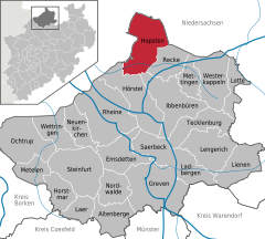
 | ||
| Coordinates: 52°22′50″N 7°36′00″E / 52.38056°N 7.60000°ECoordinates: 52°22′50″N 7°36′00″E / 52.38056°N 7.60000°E | ||
| Country | Germany | |
| State | North Rhine-Westphalia | |
| Admin. region | Münster | |
| District | Steinfurt | |
| Government | ||
| • Mayor | Winfried Pohlmann (SPD) | |
| Area | ||
| • Total | 99.8 km2 (38.5 sq mi) | |
| Population (2015-12-31)[1] | ||
| • Total | 7,642 | |
| • Density | 77/km2 (200/sq mi) | |
| Time zone | CET/CEST (UTC+1/+2) | |
| Postal codes | 48496 | |
| Dialling codes | 05458 | |
| Vehicle registration | ST | |
| Website | www.hopsten.de | |

Hopsten is a municipality in the district of Steinfurt, in North Rhine-Westphalia, Germany. It is situated approximately 15 km northeast of Rheine and 25 km southeast of Lingen.
Gallery
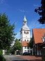 Catholic Church
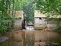 Mill Halverde
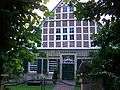 Haus Nieland
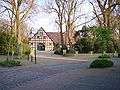 Hof Holling on the Brennikmeyer Street
| Wikimedia Commons has media related to Hopsten. |
Towns and municipalities in Steinfurt (district) | ||
|---|---|---|
References
- ↑ "Amtliche Bevölkerungszahlen". Landesbetrieb Information und Technik NRW (in German). 18 July 2016.
This article is issued from Wikipedia - version of the 5/18/2015. The text is available under the Creative Commons Attribution/Share Alike but additional terms may apply for the media files.