Hernani, Eastern Samar
| Municipality of Hernani | ||
|---|---|---|
| Municipality | ||
| ||
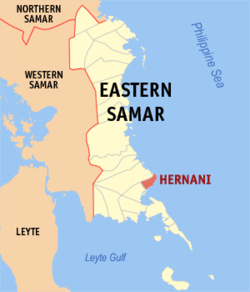 Map of Eastern Samar with Hernani highlighted | ||
.svg.png) Municipality of Hernani Location within the Philippines | ||
| Coordinates: 11°20′N 125°35′E / 11.33°N 125.58°ECoordinates: 11°20′N 125°35′E / 11.33°N 125.58°E | ||
| Country | Philippines | |
| Region | Eastern Visayas (Region VIII) | |
| Province | Eastern Samar | |
| Congr. district | Lone district of E. Samar | |
| Established | 1926 | |
| Barangays | 13 | |
| Government[1] | ||
| • Mayor | Edgar C. Boco | |
| Area[2] | ||
| • Total | 49.42 km2 (19.08 sq mi) | |
| Population (2015 census)[3] | ||
| • Total | 8,573 | |
| • Density | 170/km2 (450/sq mi) | |
| Time zone | PST (UTC+8) | |
| Website |
hernani-esamar | |
Hernani is a fifth class municipality in the province of Eastern Samar, Philippines. According to the 2015 census, it has a population of 8,573 people.[3]
It was formerly called Nag-as, after the name of the river flowing southeast of the town center.[4]
Barangays
Hernani is politically subdivided into 13 barangays. Four barangays, located in the poblacion, are known primarily by number:[2]
- Barangay 1
- Barangay 2
- Barangay 3
- Barangay 4
- Batang
- Canciledes
- Carmen
- Garawon
- Nagaja
- Padang
- San Miguel
- San Isidro
- Cacatmonan
Demographics
| Population census of Hernani | ||
|---|---|---|
| Year | Pop. | ±% p.a. |
| 1990 | 6,840 | — |
| 1995 | 8,055 | +3.11% |
| 2000 | 7,642 | −1.12% |
| 2007 | 7,974 | +0.59% |
| 2010 | 8,070 | +0.44% |
| 2015 | 8,573 | +1.16% |
| Source: Philippine Statistics Authority[3][5][6] | ||
The population of Hernani in the 2015 census was 8,573 people,[3] with a density of 170 inhabitants per square kilometre or 440 inhabitants per square mile.
References
- ↑ "Municipalities". Quezon City, Philippines: Department of the Interior and Local Government. Retrieved 24 April 2013.
- 1 2 "Province: Eastern Samar". PSGC Interactive. Makati City, Philippines: National Statistical Coordination Board. Retrieved 24 April 2013.
- 1 2 3 4 "Region VIII (EASTERN VISAYAS)". Census of Population (2015): Total Population by Province, City, Municipality and Barangay (Report). PSA. Retrieved 20 June 2016.
- ↑ "History of Hernani". Municipality of Hernani, Eastern Samar. Retrieved 24 April 2013.
- ↑ "Total Population by Province, City, Municipality and Barangay: as of May 1, 2010" (PDF). 2010 Census of Population and Housing. National Statistics Office. Retrieved 24 April 2013.
- ↑ "Province of Eastern Samar". Municipality Population Data. LWUA Research Division. Retrieved 20 August 2013.
External links
- Hernani E. Samar Official Website
- Philippine Standard Geographic Code
- Philippine Census Information
- Local Governance Performance Management System
 |
Llorente | |
Philippine Sea | |
| |
||||
| ||||
| | ||||
| General MacArthur | Matarinao Bay Salcedo |
Philippine Sea |
Borongan (capital) | |
| Municipalities | |
| Component city | |
This article is issued from Wikipedia - version of the 12/3/2016. The text is available under the Creative Commons Attribution/Share Alike but additional terms may apply for the media files.