Harmon, Oklahoma
| Harmon, Oklahoma | |
|---|---|
| Unincorporated community | |
 Harmon | |
| Coordinates: 36°08′41″N 99°33′37″W / 36.14472°N 99.56028°WCoordinates: 36°08′41″N 99°33′37″W / 36.14472°N 99.56028°W | |
| Country | United States |
| State | Oklahoma |
| County | Ellis |
| Elevation | 2,497 ft (761 m) |
| Time zone | Central (CST) (UTC-6) |
| • Summer (DST) | CDT (UTC-5) |
| Area code(s) | 580 |
| GNIS feature ID | 1093546[1] |
Harmon is an unincorporated community in Ellis County, Oklahoma, United States.[1] Harmon is located on U.S. Route 60 12 miles (19 km) east of Arnett.
References
Municipalities and communities of Ellis County, Oklahoma, United States | ||
|---|---|---|
| Towns | 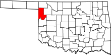 | |
| Unincorporated communities | ||
This article is issued from Wikipedia - version of the 3/10/2016. The text is available under the Creative Commons Attribution/Share Alike but additional terms may apply for the media files.