Grebenstein
| Grebenstein | ||
|---|---|---|
| ||
 Grebenstein | ||
Location of Grebenstein within Kassel district 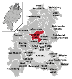 | ||
| Coordinates: 51°27′N 09°25′E / 51.450°N 9.417°ECoordinates: 51°27′N 09°25′E / 51.450°N 9.417°E | ||
| Country | Germany | |
| State | Hesse | |
| Admin. region | Kassel | |
| District | Kassel | |
| Government | ||
| • Mayor | Armin Kölling | |
| Area | ||
| • Total | 49.85 km2 (19.25 sq mi) | |
| Population (2015-12-31)[1] | ||
| • Total | 5,808 | |
| • Density | 120/km2 (300/sq mi) | |
| Time zone | CET/CEST (UTC+1/+2) | |
| Postal codes | 34393 | |
| Dialling codes | 05674 | |
| Vehicle registration | KS or HOG | |
| Website | www.stadt-grebenstein.de | |

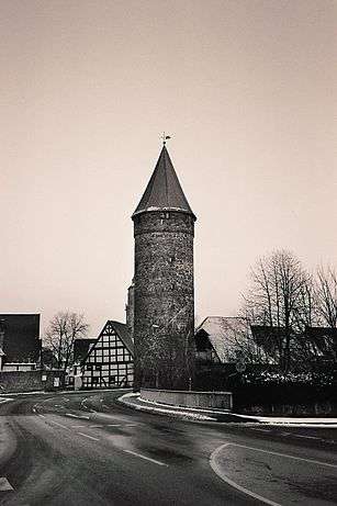
One of the historic towers on the town wall of Grebenstein
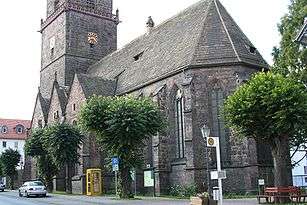
Parish church, as at 23.9.2005
Grebenstein is a town in the district of Kassel, in Hesse, Germany. It is located 16 km northwest of Kassel on the German Timber-Frame Road. In 1762 it was the scene of a skirmish between British and French troops during the Seven Years' War.
References
- ↑ "Bevölkerung der hessischen Gemeinden". Hessisches Statistisches Landesamt (in German). August 2016.
External links
- City's Homepage (German)
| Wikimedia Commons has media related to Grebenstein, Germany. |
Towns and municipalities in Kassel district | ||
|---|---|---|
This article is issued from Wikipedia - version of the 7/29/2016. The text is available under the Creative Commons Attribution/Share Alike but additional terms may apply for the media files.