Goianésia do Pará
| Goianésia do Pará | |
|---|---|
| Municipality | |
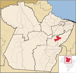 Location in Pará state | |
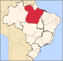
 Goianésia do Pará Location in Brazil | |
| Coordinates: 03°50′34″S 49°05′49″W / 3.84278°S 49.09694°WCoordinates: 03°50′34″S 49°05′49″W / 3.84278°S 49.09694°W | |
| Country |
|
| Region | North Region |
| State | Pará |
| Area | |
| • Total | 7,024 km2 (2,712 sq mi) |
| Elevation | 103 m (338 ft) |
| Population (2015) | |
| • Total | 37,975 |
| • Density | 5.4/km2 (14/sq mi) |
| Time zone | BRT (UTC-3) |
Goianésia do Pará is a municipality, and municipal seat in the state of Pará, Brazil. In 2015 the population was 37,975. The municipal area is 7,024 km2. The city of Goianésia do Pará is approximately 103 m above sea level.[1]
References
- ↑ "IBGE | Cidades | Pará | Goianésia do Pará". cidades.ibge.gov.br. Retrieved 2016-05-19.
External links
- for demographics and statistics (Portuguese)
Capital: Belém | |||||||||||||||||||||||||||
| Mesoregion Baixo Amazonas |
|  | |||||||||||||||||||||||||
| Mesoregion Marajó |
| ||||||||||||||||||||||||||
| Mesoregion Metropolitana de Belém |
| ||||||||||||||||||||||||||
| Mesoregion Nordeste Paraense |
| ||||||||||||||||||||||||||
| Mesoregion Sudeste Paraense |
| ||||||||||||||||||||||||||
| Mesoregion Sudoeste Paraense |
| ||||||||||||||||||||||||||
This article is issued from Wikipedia - version of the 5/19/2016. The text is available under the Creative Commons Attribution/Share Alike but additional terms may apply for the media files.