Getap, Aragatsotn
For other uses, see Getap.
Coordinates: 40°23′14″N 43°37′18″E / 40.38722°N 43.62167°E
| Getap Գետափ | |
|---|---|
 Getap | |
| Coordinates: 40°23′14″N 43°37′18″E / 40.38722°N 43.62167°E | |
| Country | Armenia |
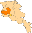
| Marz (Province) | Aragatsotn |
| Population (2001) | |
| • Total | 183 |
| Time zone | (UTC+4) |
| • Summer (DST) | (UTC+5) |
Getap (Armenian: Գետափ, also Romanized as Getap’ and Getar; until 1946, Karakula or Gharaghla[1]) is a town in the Aragatsotn Province of Armenia.
References
- ↑ Kiesling, Rediscovering Armenia, p. 20, available online at the US embassy to Armenia's website
This article is issued from Wikipedia - version of the 11/22/2016. The text is available under the Creative Commons Attribution/Share Alike but additional terms may apply for the media files.