General Salgado
| General Salgado | ||
|---|---|---|
| Municipality | ||
| ||
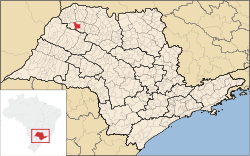 Location of General Salgado | ||
 General Salgado Location of General Salgado | ||
| Coordinates: 20°38′52″S 50°21′39″W / 20.64778°S 50.36083°WCoordinates: 20°38′52″S 50°21′39″W / 20.64778°S 50.36083°W | ||
| Country |
| |
| Region | Southeast | |
| State |
| |
| Area | ||
| • Total | 493.3 km2 (190.5 sq mi) | |
| Elevation | 418 m (1,371 ft) | |
| Population (2010/IBGE) | ||
| • Total | 10,669 | |
| • Density | 22/km2 (56/sq mi) | |
| Time zone | UTC-3 (UTC-3) | |
| • Summer (DST) | UTC-2 (UTC-2) | |
| Postal Code | 15300-000 | |
| Area code(s) | +55 17 | |
| Website | Prefecture of General Salgado | |

General Salgado is a municipality in the state of São Paulo, Brazil. The city has a population of 10,669 inhabitants and an area of 493.3 km².[1]
General Salgado belongs to the Mesoregion of São José do Rio Preto.
References
- ↑ "2010 Census of the IBGE - Population - Table 2.1.20" (PDF) (in Portuguese). IBGE.gov.br. Retrieved 11 June 2012.
This article is issued from Wikipedia - version of the 5/14/2016. The text is available under the Creative Commons Attribution/Share Alike but additional terms may apply for the media files.